

Latest Weather Blog
Tuesday PM Forecast: showers and humidity hold on ahead of weak front
Showers remain in the forecast for two more days. A cold front, in definition only, will move into the region Thursday afternoon and then provide a bit drier conditions.
Next 24 Hours: Overnight, skies will be partly cloudy with low temperatures slipping into the mid 70s. Wednesday will see a mix of sun and clouds with scattered showers, still related to Ida. There will be plenty of dry time and high temperatures are expected to run into the upper 80s. With ample humidity, feels-like temperatures will be near 100 degrees. The National Weather Service has issued a HEAT ADVISORY with lower criteria than usual given the circumstances of no electricity, no air conditioning and the extra time being spent working outdoors.
Up Next: On Thursday, a weak cold front will slide into the area from the northeast. This boundary will help to spark a couple of showers and thunderstorms—especially during the afternoon hours. The passage of that boundary will allow drier, less humid air to push in for Friday and the weekend. High temperatures will remain warm in the upper 80s and low 90s but nights will be a bit more comfortable. Low temperatures will slip below average in the upper 60s and low 70s. Rain chances will be very low through Sunday. CLICK HERE for your full 7-Day Forecast.
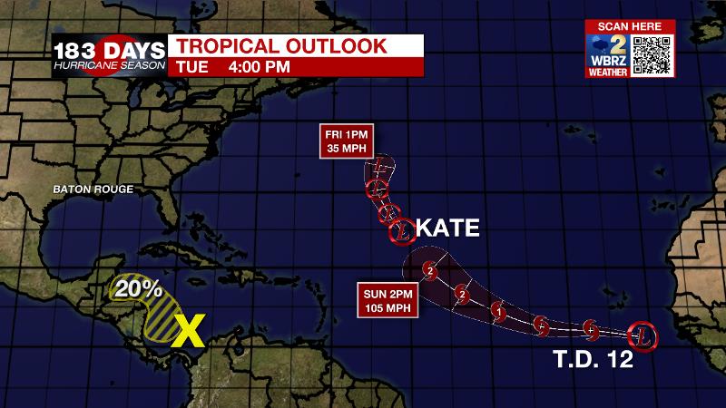
The Tropics: As of 4pm Tuesday, the remnants of Ida were pushing northeast through the Tennessee River Valley. Flooding rain and isolated tornadoes will remain a threat through much of the Mid-Atlantic and Northeast regions.
Trending News
As of 4pm Tuesday, Tropical Depression Kate was drifting north across the east, central Atlantic with maximum sustained winds of 35mph. This system is forecast to remain weak before dissipating by Friday, well east of Bermuda.
Tropical Depression 12 has developed off the west coast of Africa. This storm will gradually strengthen, becoming tropical storm Larry and eventually a hurricane over the eastern Atlantic. The latest forecast track carries this system west-northwestward across the open, central Atlantic.
A broad area of low pressure is expected to form in the southern Caribbean Sea by midweek. There is a 20 percent chance of some slow development by the end of the week, as long as the system remains over water. This system is expected to move gradually west-northwestward or northwestward at 5 to 10 mph over the western Caribbean Sea near the east coast of Central America.
For the latest tropical forecasts, advisories and information, visit the WBRZ Hurricane Center as we navigate all 183 Days of Hurricane Season.
The Explanation: On Wednesday, a weak surface trough associated with the remnants of Ida will remain draped across southeast Louisiana. This feature will allow scattered showers and thunderstorms to develop and as it becomes more diffuse across the area that should allow activity to develop north of the interstates as well, unlike Tuesday. While average heat and humidity for the time of year is anticipated, the lack of air conditioning around the area will cause a greater likelihood of heat related illness. There the National Weather Service has issued heat advisories to heighten awareness. Thursday, a weak cold front will move in from the northeast to spark a few more showers and thunderstorms. This feature should pass the local area with enough integrity to lower humidity as far south as I-10. On the other side of that front, dew point temperatures will dip into the upper 50s and low 60s. This will, decrease rain chances, allow humidity to break and low temperatures to trail off into the upper 60s, especially north of the highways. Southeast winds and some humidity will creep back into the area next week also returning the possibility of a few showers.
--Josh
The WBRZ Weather Team is here for you, on every platform. Your weather updates can be found on News 2, wbrz.com, and the WBRZ WX App on your Apple or Android device. Follow WBRZ Weather on Facebook and Twitter for even more weather updates while you are on the go.
More News
