

Latest Weather Blog
Tuesday PM Forecast: cloudy and muggy ahead of storms on Thursday
The gray and mild conditions will last into Thursday. The next cold front is expected then with rain and perhaps a few strong thunderstorms.
Tonight & Tomorrow: Mainly cloudy skies and south winds of 10-20mph will persist overnight. An isolated shower will be possible. Low temperatures will bottom in the mid 60s. Wednesday will be another one with lots of clouds and a few showers. High temperatures will be well above average in the upper 70s with south winds of 10-15mph.
Up Next: Mild air will remain into Thursday as the next cold front approaches. This system will bring rain and thunderstorms, mainly during the first half of Thursday. At this time, there is a 2/5 “Slight Risk” for severe weather, especially north and east of Baton Rouge. A sharply colder air mass will trail the front Thursday night into Friday and temperatures will dive into the upper 30s. Despite sunshine, high temperatures will remain in the low 50s on Friday. The Mardi Gras Weekend will be dry with near freezing temperatures to begin Saturday followed by a high in the upper 50s and then a high in the mid 60s on Sunday.
Get the latest 7-day forecast and real time weather updates HERE.
Watch live news HERE.
Trending News
Detailed Forecast: An upper level ridge of high pressure will control the local weather pattern through Wednesday evening. Southerly winds at the surface will advance more and more moisture into the region. A weak upper level trough of low pressure will swing north of the area, with a weakening cold front, dissipating to the north as well. These features may generate just enough lift for one or two showers on Tuesday and Wednesday, but widespread, organized rain is not expected. A stronger upper level trough of low pressure will extend out of the Southwest U.S. and into the Midwest on Thursday. A surface low and associated front will form as this happens and start to move east across the Southern U.S. The trough is expected to open up into an orientation that is a little less favorable for severe weather, but does not mean the threat and ingredients will be zero, rather just a bit more typical.
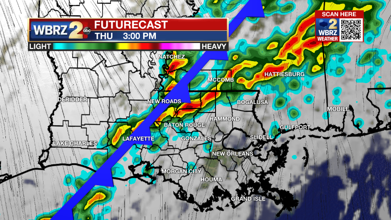
The front is expected to move in during the first half of the day Thursday which will mean that surface warming and instability could be a little bit lacking. On the flip side, moisture, low level winds and spin in the atmosphere will be supportive of severe weather, especially north of I-12. So, this is the usual conditional threat for severe weather where a short window may exist where the ingredients come together. Of course, more details will become clearer as we get closer. The front will charge through on Thursday night with gusty northerly winds. Friday will be sunny, brisk and cold with highs in the 50s. A surface high pressure system will park over the Mid-South on Friday night into Saturday leading to lighter winds and clear skies to maximize cooling in the region. It is possible a few spots north and east of Baton Rouge get close to freezing my Saturday morning. Temperatures will gradually warm through the rest of the weekend with cool mornings giving way to mild and dry afternoons. The next chance for rain will come during the early to middle part of next week, we will monitor closely to see if this plays a role in the Lundi Gras or Mardi Gras forecast.
--Josh
The Storm Station is here for you, on every platform. Your weather updates can be found on News 2, wbrz.com, and the WBRZ WX App on your Apple or Android device. Follow WBRZ Weather on Facebook and Twitter for even more weather updates while you are on the go.
More News
