

Latest Weather Blog
Tuesday Evening Forecast: soggy summer pattern to change soon
Wet weather will hold on for another 24 hours or so. However, a clear pattern transition will start to take place toward the end of the week.
Next 24 Hours: A damp, muggy night is expected. Although a constant rain is not expected, scattered showers will stay in the forecast. Another heavy batch, similar to what occurred on the Northshore Tuesday morning, is not expected. Low temperatures will stop in the low 70s. Wednesday will not be as wet as Tuesday. Scattered showers and thunderstorms are anticipated but with many more dry intervals comparatively. Even some breaks of sun will be available. High temperatures will chug into the upper 80s during those times of clearing.
Up Next: By Thursday and Friday, activity will be categorized as more “normal” for the time of year with just isolated, afternoon showers. In fact, through the weekend, many locations could go entire days without rain! That has been difficult to do lately. Keep in mind, drier times in the summer usually mean much more heat and steam. There are signs that a very warm pattern could develop by the middle of next week. CLICK HERE for your full 7-Day Forecast.
The Tropics: For the North Atlantic, Caribbean Sea and Gulf of Mexico, no tropical development is expected over the next five days. For the latest tropical forecasts and information, visit the WBRZ Hurricane Center as we navigate all 183 Days of Hurricane Season.
Trending News
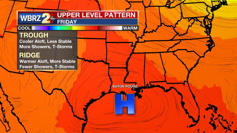
The Explanation: An upper level trough is expected to cut off over Texas on Wednesday before being absorbed by the jet stream. An associated weak front will remain stalled across Louisiana and Mississippi. All the while, atmospheric moisture remains well above average. These features will hold scattered showers and thunderstorms in the forecast through Wednesday, but with a little less energy and lift in the atmosphere, action should be a bit more sporadic. Though widespread flooding is still not a concern, localized street and poor drainage flooding is always possible as was the case on the Northshore Tuesday morning. An upper level ridge will finally begin to build over the local area on Thursday and especially Friday. Since atmospheric moisture will stay elevated, showers and thunderstorms will not end entirely, but should be much more isolated and limited to the peak heating hours of the afternoon. While the ridge could buckle a bit over the weekend, it is expected to build firmly overhead by the middle of next week. This could spell very high heat and humidity for the central Gulf Coast.
--Josh
The WBRZ Weather Team is here for you, on every platform. Your weather updates can be found on News 2, wbrz.com, and the WBRZ WX App on your Apple or Android device. Follow WBRZ Weather on Facebook and Twitter for even more weather updates while you are on the go.
More News
