

Latest Weather Blog
Thursday PM Forecast: moving into a wetter weather pattern this weekend
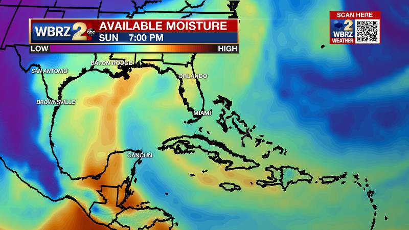
The weather pattern will transition into the weekend. A deep flow of tropical moisture will bring widespread, and at times heavy, showers and thunderstorms to the region.
Next 24 Hours: Tonight will be mostly clear with low temperatures in the low 70s. The workweek will end with a repeat of mostly sunny skies and high temperatures in the low 90s.
Up Next: By the weekend, a weak front moving into the area will bring a significant uptick in the numbers of showers and thunderstorms. The front will not yet be here by Saturday, so action will fire up in the afternoon as high temperatures climb into the low 90s. A few showers and thunderstorms will then be possible overnight thanks to the advancing front. As it stalls over the area, Sunday and Monday look to be busy with widespread showers and thunderstorms. While the broad rainfall forecast calls for 2-4 inches through next week, especially on Sunday night and Monday, a few small areas could receive much higher amounts in any persistent thunderstorms. As we know is typical during the warm season, this could create some localized street and poor drainage flooding. The remnants of the front will continue to instigate afternoon showers and thunderstorms on Tuesday and Wednesday. While the rain may dampen some outdoor events, it will generally be beneficial to the Capital Area which is considered “severely dry” in the U.S. Drought Monitor. CLICK HERE for your detailed 7-Day Forecast.
The Tropics: The National Hurricane Center has started issuing official, tropical weather outlooks. While this was previously done on the first day of hurricane season, June 1, last year the NHC decided to start outlooks earlier due to the recent string of pre-season tropical systems. In this year's first outlook, no development is expected over the next 5 days.
Trending News
The Explanation: An upper level ridge of high pressure will weaken on Friday. Despite this, drier air in the atmosphere should continue to promote a quiet weather pattern with high temperatures still climbing into the low 90s. By Saturday afternoon, cooling temperatures aloft will promote instability while southwesterly upper level winds transport moisture back into the region. With the daytime warming, scattered showers and thunderstorms will develop across southeast Louisiana and southwest Mississippi. With a weak front entering the region, a trigger may remain in place for some activity to continue overnight Saturday into Sunday. A deep feed of moisture originating from the Caribbean Sea will surge across the region pushing atmospheric moisture content to very high levels. With that front moving closer to the region and slowing down on Sunday, there will be a clear forcing mechanism in addition to the favorable conditions provided by the cooler, more unstable atmosphere and added moisture. Numerous to widespread showers and thunderstorms will carry through the second half of the weekend and into early next week. Though the timing is not ideal for outdoor plans, this rain will be beneficial to most areas considered to be in drought and it will help to keep high temperatures in the 80s. Even Tuesday and Wednesday, the pattern will stay favorable for episodes of heavy rain with a continued feed of moisture across the region and a weakening, but stalled boundary providing a focus for development. Southwest winds in the upper levels favor disturbances rolling over the area, which will trigger rounds of activity. Since these little impulses tend to be very subtle, they may be difficult for us to detect and time out until next week. Daytime warming and marine breezes will certainly play a role in development as well, making the middle of the day the most likely time for activity.
--Josh
The Storm Station is here for you, on every platform. Your weather updates can be found on News 2, wbrz.com, and the WBRZ WX App on your Apple or Android device. Follow WBRZ Weather on Facebook and Twitter for even more weather updates while you are on the go.
More News
