

Latest Weather Blog
Thursday AM Forecast: Another rainy afternoon today, A bit more sunshine to end the week
There will be more dry time this morning before showers and storms scatter over the area this afternoon.
THE FORECAST
Today & Tonight: Showers and storms will be back this afternoon. Before then, it will be muggy, temperatures will max out in the low 80s with overcast skies. Some showers will bring a brief heavy downpour, keep an eye out for street and poor drainage flooding in low lying areas. Overnight the showers will clear out and temperatures will be near 70 degrees.
Up Next: Starting Friday, the rain coverage will be much less with just a few showers passing by. Temperatures will continue to trend in the mid-80s with high humidity. Saturday and Sunday will bring isolated to scattered showers in the afternoon. Saturday tailgates should prepare for a passing shower or two in the afternoon and evening. Weekend temperatures will be in the mid-80s. In the middle of next week, a front is forecast to move through the area. Showers and storms will spark up along it on Monday and parts of Tuesday. By Wednesday, dew points and rain coverage will show some significant drop. Click here to see the 7-day forecast.
In the Tropics:
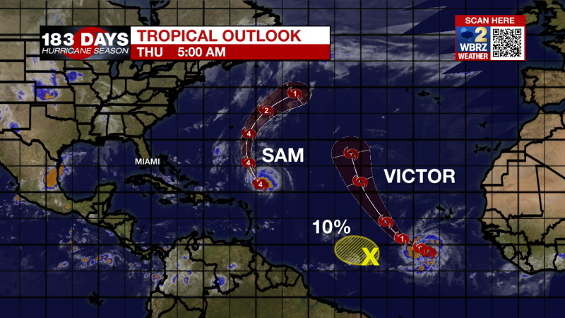
While there is a lot of activity in the Atlantic basin, none of it is currently a threat to the local area.
Trending News
Hurricane Sam is holding on to category 4 status. Winds are currently at 145 mph and is moving northwest at 12 mph. Sam is expected to make a turn off to the northeast and bypass Bermuda over the weekend.
Tropical Storm Victor was named yesterday. It is currently just off the coast of Africa, has winds near 45 mph and is moving west-northwest at 14 mph. It is expected to make a turn to the north and stay in the open Atlantic.
Shower activity associated with a trough of low pressure located over the tropical Atlantic about midway between the Cabo Verde Islands and the Lesser Antilles has become limited. Environmental conditions are forecast to become less conducive over the next few days, and significant development of this system is no longer anticipated. The disturbance is forecast to move westward at 10 to 15 mph. Formation chances have dropped to 10% for the next 48 hours.
The WBRZ Weather Team is watching the tropics around the clock and will bring you updates as they come. Click here to visit the Hurricane Center.
Need weather conditions HOUR BY HOUR? Get hour by hour weather and right now weather conditions for your location on the WBRZ WX App on your Apple or Android device. Follow WBRZ Weather on Facebook and Twitter for even more weather updates and unique weather insight from the whole team!
More News
