

Latest Weather Blog
The calm before the tropical showers and storms
Thursday will be dry with low humidity and tropical showers will be moving in tomorrow.
THE FORECAST
Today & Tonight: Temperatures will again be in the 90s, but the humidity will be milder today. This is the last dry day in the forecast with mostly sunny skies. Overnight temperatures will be near 70 degrees.
Up Next: Friday morning the tropical moisture will move in. Scattered showers will start up in the late morning hours and Friday showers will be scattered in nature all day long. These showers and storms will be fueled by Gulf moisture and will be capable of producing a lot of rain in a short amount on time. A few inches of rain accumulation will be possible across the area by the end of the day Friday. Temperatures will max out in the 80s.
Saturday is setting up to be the wettest day in the forecast. Periods of heavy rain will start in the morning. With the current forecast, the heaviest rain is likely to be on the eastern edges of the WBRZ viewing area and even further east into Mississippi and Alabama. The tropical system will track northeast all day and the afternoon and evening hours will likely see fewer showers in number. The afternoon and evening activity will still be capable of producing those heavy downpours.
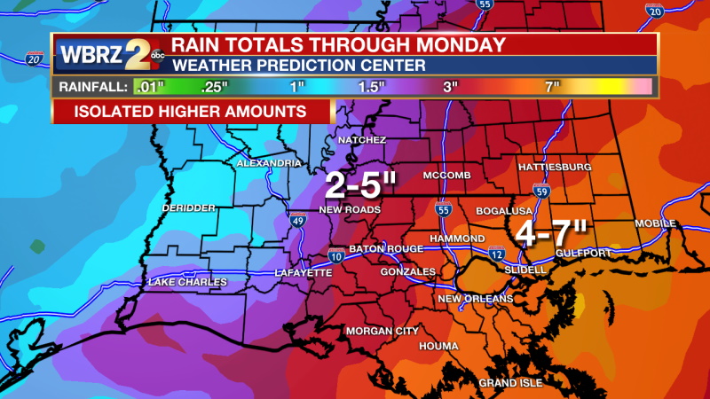
As the system moves away from our area on Sunday, some shower activity will linger. Scattered showers will be possible for the entire day and with deep tropical moisture more downpours. Adding up all the rainy days, the highest totals with be between 4-7 inches on the far east side of the viewing area. Totals of 2-5 inches will be the case for areas further west. Isolated higher amounts are expected. Once the disturbance in the Gulf fully develops, all the details will unfold, and we will likely see flash flood watches issued for the areas at the highest risk for flooding. Continue to check back for daily updates. Scroll down for more on the tropics. Click here to see the 7-day forecast.
Trending News
In the Tropics:
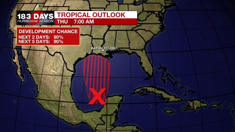
Thursday 1am Tropical Outlook
Confidence in the forecast for this system continues to increase. Development into a tropical depression is expected late today or early tomorrow. There is already some northward movement of the storm and that is expected until the storm reaches the Gulf Coast over the weekend. It won’t have much time to organize before reaching the Gulf Coast, this means it will likely be lopsided with the east side of the storm seeing most of the rain. Gusty winds will come along with tropical showers and storms. Click here to visit the WBRZ Hurricane Center.
Reminder: With the threat for impactful weather—tropical thunderstorms—please have access to alerts through Saturday. You can download or activate the WBRZ WX App on your Apple or Android device or turn on a NOAA Weather Radio for bulletins such as watches and urgent warnings. Of course, WBRZ, WBRZ+ and the Cable Weather Channel will have updates as active weather dictates.
More News
