

Latest Weather Blog
Sunday AM Forecast: Less rain expected today and Monday
Sunday Funday again this weekend. If you have outdoor plans today is the day to do them!
THE FORECAST
Today & Tonight: Waking up to mostly sunny skies across the Capital Area this Sunday. Sunshine will be sticking around for most of the day. Today will trend much drier and a little bit warmer than what we saw yesterday. Temperatures will top out around the average 93° mark. Cloud cover and showers are not out of the picture, but we are not forecasting widespread rain. Isolate showers are possible during the afternoon hours. Most people will be able to stay completely dry. The showers that do develop will be short lived and out of the area by the evening hours. Overnight temperatures fall back into the mid-70s.
Up Next: Monday morning will still be sticky. We are seeing some drying out in the forecast but not enough to move the humidity out of our area. Mostly sunny skies are expected at the start of the day. Temperatures will rise back into the low-to-mid 90s. Showers are possible during the afternoon hours. With winds out of the northeast showers will move from the Mississippi/Louisiana border southwestward into the Capital Area. Showers will be brief and timing will be in the afternoon hours. After Monday the chance for isolated showers begins to lower. For Tuesday and the rest of the work week more moisture will begin surging back into the area. Moisture plus warm temperatures are the perfect recipe for an afternoon shower and we are expecting widespread rain later in the week. Click here to see the 7-day forecast.
Don’t let sneaky showers catch you off guard this workweek. Hour-by-hour weather tracking is available for your location on the WBRZ WX App on your Apple or Android device. Follow WBRZ Weather on Facebook and Twitter for even more weather updates and unique weather insight from the whole team!
In the Tropics:
Trending News
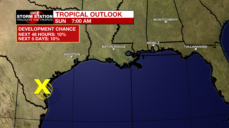
Northwestern Gulf of Mexico:
Shower and thunderstorm activity has increased early this morning
in association with an area of low pressure area located near the
coast of Texas just south-southeast of Corpus Christi. Surface and
radar observations indicate that the circulation has become a
little better defined, however the center is expected to move
inland over southern Texas this morning and further significant
development is not anticipated. Regardless of development, heavy
rains are forecast across southern Texas through Monday, which could
cause localized areas of flash flooding. For more information about
the potential for heavy rainfall, please see products issued by
your local National Weather Service office and the Weather
Prediction Center.
* Formation chance through 48 hours...low...10 percent.
* Formation chance through 5 days...low...10 percent.
More News
