

Latest Weather Blog
Saturday PM Forecast: Sunday will be a near repeat, expect more clouds
Just two more dry days in the forecast before some much needed rain.
THE FORECAST
Tonight & Tomorrow: Cloud cover will continue to build in as we head into the overnight hours. Temperatures will fall back into the high-50s. Some low level moisture could have some areas seeing patchy fog in the morning. Quickly starting your Sunday we will see southerly winds pick up and temperatures will start to climb. Daytime highs will top out in the mid-80s. With plenty of moisture in our area, cloud cover will stick around for most of the day. Not expecting any showers in the forecast just yet. Overnight the pattern will repeat into the start of your workweek.
Up Next: Monday will be a near repeat of Sunday with humid, and warm conditions. You will start your day feeling muggy with temperatures in the mid-60s. Throughout the day more cloud cover builds in as temperatures reach the mid-80s. Rain will stay out of the forecast for just one more day before a cold front brings some much need showers into the area on Tuesday. The timing of the cold front is key. If the front moves through earlier in the morning hours we will likely just see light showers and the drying out. If the front stalls out and moves through later into the afternoon we would then have a threat for some severe weather. If showers and thunderstorms develop along the frontal boundary we could see gusty winds, lighting, and hail. Regardless most areas will see some rain. Once the front pushes through we will be back feeling more like fall again. Click here to see the 7-day forecast.
Quick cold front moving through, do not let sneaky showers catch you off guard. The Storm Station has you covered with hour-by-hour weather tracking is available for your location on the WBRZ WX App on your Apple or Android device. Follow WBRZ Weather on Facebook and Twitter for even more weather updates and unique weather insight from the whole team!
Trending News
In the Tropics:
The viewing area will not be impacted if this system develops.
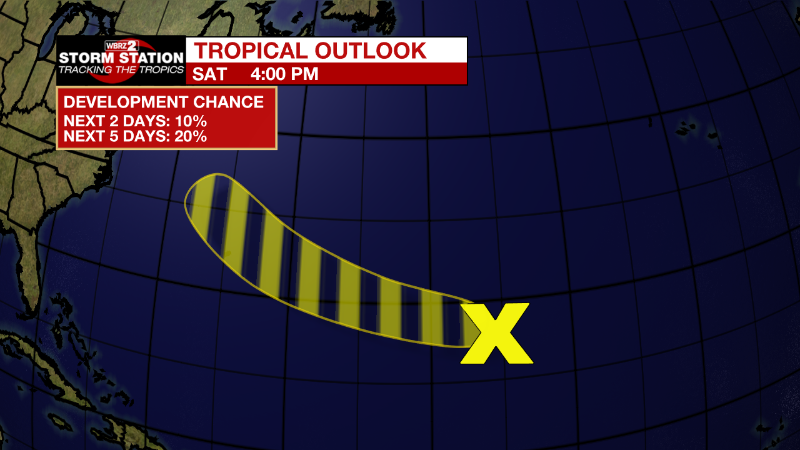
Central Subtropical Atlantic:
A trough of low pressure located well to the east of Bermuda is
producing limited shower activity. Although environmental conditions
are only marginally conducive for development during the next few
days, the disturbance could still acquire some subtropical or
tropical characteristics by early next week while it moves westward
to west-northwestward at 15 to 20 mph across the subtropical
Atlantic. By the middle part of next week, further development
appears unlikely while the system moves northwestward over cooler
waters of the northwestern Atlantic and encounters stronger
upper-level winds. Additional information on this system, including
gale warnings, can be found in High Seas Forecasts issued by the
National Weather Service.
* Formation chance through 48 hours...low...10 percent.
* Formation chance through 5 days...low...20 percent.
More News
