Saturday PM Forecast: Record breaking heat again today, possibility for more tomorrow
Sunday will be another hot one but BIG changes to come for the work week.
THE FORECAST
Tonight & Tomorrow: Another day with record heat for the Capital Area. Temperatures this afternoon broke the record at 97°, the previous record of 96° was set in 1931. Only a few clouds in the skies this afternoon, and those will begin to clear out as we head into the overnight hours. Temperatures will quickly drop into the low-70s. For Sunday expect to wake up with partly sunny conditions. Moisture moves in and sets up early leaving us with cloudy conditions to start your day. A shower is possible in the afternoon hours, but most will stay completely dry. A cold front is expected to push through the area later in the evening. As winds shift out of the north we will begin to see much cooler, drier conditions.
Up Next: Waking up Monday morning some moisture will still be lingering in our area, and the effects of the cold front will not have fully set in yet. We will still be trying to break up this summertime pattern for most of the day. Daytime highs will top out in the low-90s, Monday afternoon. However, as the cold front really sets into the area and we begin to see winds shift out of the north, and we are expecting a more fall like forecast. By Tuesday morning we begin to see more changes in the forecast. Waking up with temperatures in the low-60s. Clear skies all day long, and temperatures much cooler than this past week. You can expect much less humidity starting Tuesday and into the rest of the work week. Everyday by the afternoon hours temperatures will be in the mid-80s. Click here to see the 7-day forecast.
The Storm Station has you covered with hour-by-hour weather tracking is available for your location on the WBRZ WX App on your Apple or Android device. Follow WBRZ Weather on Facebook and Twitter for even more weather updates and unique weather insight from the whole team!
Trending News
In the Tropics:

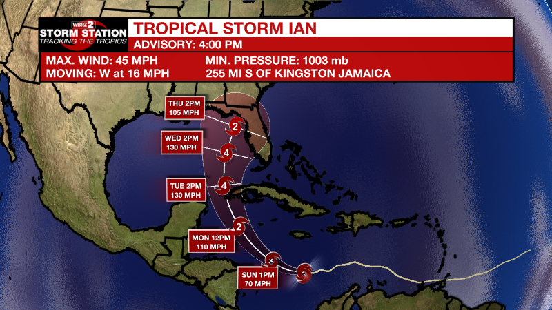
Tropical Storm Ian formed on Friday morning in the central Caribbean Sea. As of 4pm Saturday maximum sustained winds remained at 45mph. By Sunday and Monday, Ian will turn to the northwest and become a hurricane on approach to the Cayman Islands. Florida could be a target of then Hurricane Ian by the middle of next week.
Fiona will bring hurricane force winds and high surf to Nova Scotia tonight and Saturday. Even though the storm will become non-tropical, it will remain powerful as it crosses into the Labrador Sea by Sunday.
Tropical Storm Gaston continues churning near the Azores with maximum winds of 50mph. The storm will bring heavy rain and wind to the islands while swinging around to the southeast and then south while gradually weakening.
Tropical Storm Hermine formed just west of the African Coast on Friday afternoon. Some heavy rain is possible in the Canary Islands before Hermine becomes a remnant low by Monday.
Central Tropical Atlantic:
Showers and thunderstorms remain disorganized in association with a
broad area of low pressure located several hundred miles
west-southwest of the Cabo Verde Islands. Despite unfavorable
upper-level winds, some slow development of this system is possible
over the next several days while it drifts northwestward or
northward over the central tropical Atlantic.
* Formation chance through 48 hours...low...10 percent.
* Formation chance through 5 days...low...30 percent.


