Saturday AM Forecast: Summertime showers expected again today
Temperatures heat up and we begin to dodge afternoon sneaky showers.
THE FORECAST
Today & Tonight: Happy Saturday! You’ve made it to the weekend, but unfortunately, we are still expecting rain. Temperatures will continue to climb into the low-90s across the Capital Area. As temperatures heat up, showers will begin bubbling up across the area. Showers and storms have the ability to drop large amounts of rain and produce frequent lightning. If you have outdoor plans, I would make indoor backup plans just in case. Showers will be cleared out of the area before any Saturday evening plans. Overnight temperatures will lower into the low-to-mid 70s and we will see some clearing out heading into Sunday.
Up Next: Sunday is a copy and paste forecast. Temperatures waking up will be in the mid-70s across the area with mostly sunny skies. Moisture will be hanging around the forecast, and as temperatures heat into the low-90s shower activity will increase. Most people will be able to dodge these showers, especially if you have the WBRZ WX App. By the evening hours, radar will calm down and temperatures will fall back into the mid-70s overnight. Monday, unfortunately, the rainy pattern is set to repeat. We will be waking up to temperatures in the low-70s feeling sticky. Throughout the day temperatures climb into the low-90s. As temperatures rise, rain chances go up. Showers and storms make their way out of the area by the evening hours leaving us with mostly clear skies overnight. The same pattern repeats for the rest of the week. Click here to see the 7-day forecast.
Don’t let sneaky showers catch you off guard this weekend. Hour-by-hour weather tracking is available for your location on the WBRZ WX App on your Apple or Android device. Follow WBRZ Weather on Facebook and Twitter for even more weather updates and unique weather insight from the whole team!
Trending News
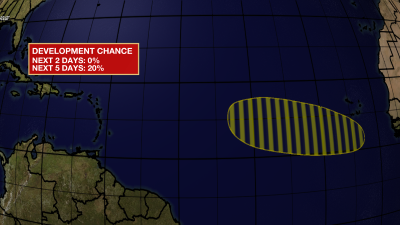
In the Tropics:

Eastern Tropical Atlantic:
A tropical wave is forecast to move off the west coast of Africa
later this weekend. Environmental conditions are expected to be
conducive for some gradual development of this system while it
moves westward across the eastern and central tropical Atlantic
during the early to middle part of next week.
* Formation chance through 48 hours...low...near 0 percent.
* Formation chance through 5 days...low...20 percent.


