

Latest Weather Blog
Moderating temperatures set the stage for next rain
The chilly mornings, and temperatures overall, will moderate through the weekend. Showers and thunderstorms are also set to reenter the forecast.
THE FORECAST:
Today and Tonight: Highs will make a run closer to average on Thursday afternoon with abundant sunshine. The top out reading near 76 degrees will occur during the mid-afternoon hours. Nighttime lows will stop near 55 degrees as winds shift east and some clouds advance into the area.
Up Next: A frontal system will gather in the Lower Midwest, bringing increasing clouds and the next chance for an isolated shower on Friday. Temperatures will return to near or slightly above average levels and last through the weekend. A cold front will settle into the region on Saturday leading to scattered showers and thunderstorms. That front will quickly reverse course as a warm front allowing another push of warmth and moisture prior to a second cold front that will kick through on Sunday. This feature will create a round of showers and thunderstorms, one or two of which could be strong. At this time, the ingredients favor the possibility of gusty wind and isolated tornadoes. Minimal temperature changes will follow early next week with a brief period of dry weather.
The Mississippi River: At Baton Rouge, major flood stage continues with a level of 43.6’ as of Thursday morning. The river is expected to fall very slowly through the next two weeks. The high water is primarily an issue for river traffic and river islands, although some inundation will continue for a few spots north and south of Baton Rouge that are not protected by levees. Unprotected low-lying areas will be flooded and agricultural operations will be impacted on the west side of the river. The grounds of the older part of Louisiana State University's campus become soggy. This includes the area around the Veterinary Medicine building, the Veterinary Medicine Annex, the stadium and ball fields. The city of Baton Rouge and the main LSU campus are protected by levees at this level. The level is also high in New Orleans and the U.S. Army Corps of Engineers has opened the Bonnet Carre Spillway.
THE EXPLANATION:
The cold front responsible for the recent cool temperatures will get reactivated as a warm front and move north on Friday. This will restore moisture to the atmosphere therefore returning clouds and isolated showers. A cold front will slide into the area Saturday continuing the chance for showers. This unorganized storm system will then stall for about a day before an upper level trough approaching from the west lifts the front back through the area. This will again load the atmosphere with moisture allowing for the upper level trough and associated cold front to produce scattered to widespread showers and thunderstorms on Sunday.
Trending News
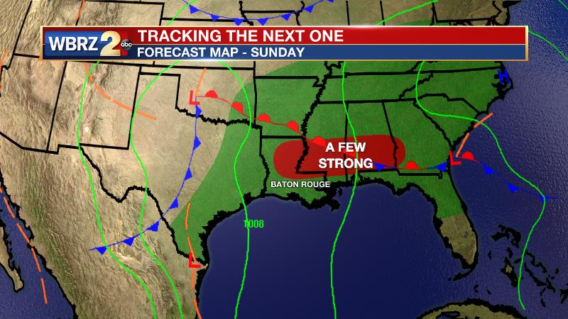
This trough will be neutral to positively tilted which is a less favorable orientation for severe weather than last weekend. There will be plenty of instability, warmth and moisture available for thunderstorms; however, the wind shear is expected to be somewhat limited. As a cold front and the upper level trough of low pressure approach, a brief afternoon overlap of the best ingredients could allow for a few strong storms. This will likely warrant a “slight” to “enhanced” risk of severe weather to the local area with the primary possibility being damaging wind gusts followed by an isolated tornado. Some light rain on the backside of this system will move out of the area Monday morning with minimal cooling behind this front.
--Josh
The WBRZ Weather Team is here for you, on every platform. Your weather updates can be found on News 2, wbrz.com, and the WBRZ WX App. on Apple and Android devices. Follow WBRZ Weather on Facebook and Twitter for even more weather updates while you are on the go.
More News
