

Latest Weather Blog
Looking out for a heavy downpour, Elsa makes landfall
It's called a “weather pattern” because it repeats over and over again.
THE FORECAST
Today & Tonight: Scattered showers will become more widespread in the late afternoon and early evening. You will likely run into some rain on your evening commute. Heavy downpours will be possible, so if you are caught driving in the rain, look out for street and poor drainage flooding. Temperatures between the showers will warm up into the mid-80s and will be back down in the 70s overnight.
Up Next: Temperatures will continue to trend just shy of 90 degrees for the rest of the week. Thursday is set to be another repeat day with scattered to widespread showers in the area, mainly in the afternoon. Starting Friday, the pattern will break up a bit with showers still in the forecast, but there will be more dry time in the day. Saturday is setting up to be the driest day of the week with rain coverage expected to be only 30% of the viewing area. Click here to see the 7-day forecast.
In the Tropics:
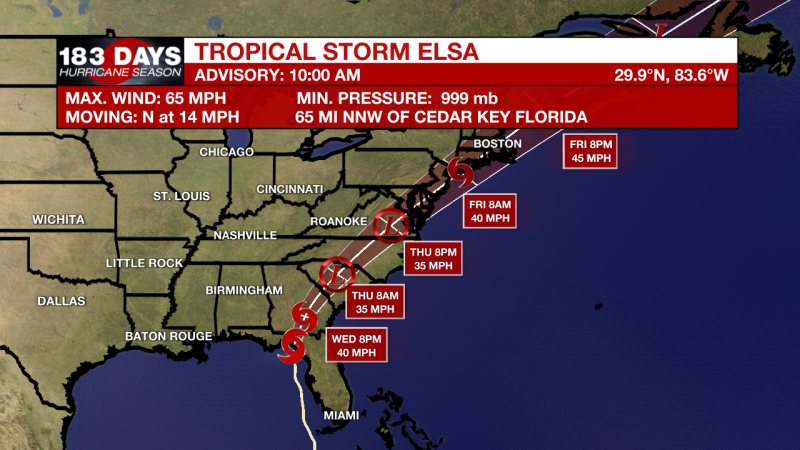
Tropical Storm Elsa made landfall in Taylor County Florida around 10 am this morning. Elsa is a tropical storm with maximum winds near 65mph after briefly re-intensifying into a category 1 hurricane on Tuesday afternoon. Elsa is bringing tropical storm conditions to much of Florida and is expected to weaken into a tropical depression in the coming day. The system is still moving north, but an easterly shift will steer Elsa over Georgia and a large portion of the East Coast over the next few days. Elsa is not forecast to impact the local area. Stay with us for timely updates. Click here to visit the WBRZ Hurricane Center.
Trending News
More News
