

Latest Weather Blog
Finally drying out on Sunday
The WBRZ viewing area is under a FLASH FLOOD WATCH through Saturday night. While heavy rain remains the main concern for our area, one or two thunderstorms could produce gusty wind and hail.
Saturday: Today will be the last gloomy day for a while. Light rain will continue to be on and off all day, especially for areas south of I-12. A few thunderstorms will be in the mix this afternoon as well. When it isn’t raining the temperatures will be in the upper 60s and low 70s at the very warmest. The clouds will start to break up overnight and temperatures will drop into the 50s.
Up Next: Once the front moves into the northeastern Gulf, drier air will filter into the region. Sunshine will join all of us for the second half of the weekend as we begin an extended quiet stretch. Through the weekend, high temperatures will hover around 70 degrees with low temperatures in the upper 50s. A reinforcing cold front should help maintain below average highs and lows, with some spots even making it into the upper 40s a few mornings next week! Continue to check back for more updated information. Click here to see the 7-day forecast.
Reminder: With the threat for impactful weather—severe thunderstorms and flooding—please have access to alerts through Saturday. You can download or activate the WBRZ WX App on your Apple or Android device or turn on a NOAA Weather Radio for bulletins such as watches and urgent warnings. Of course, WBRZ, WBRZ+, and the Cable Weather Channel will have updates as weather dictates.
River Stages
Trending News
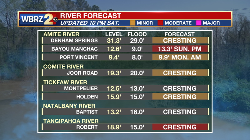
Amite River at Bayou Manchac: Forecast Crest of 13Ft
At 10 Feet: Amite River Road and Horseshoe Drive will be impassable. A few homes on Horseshoe Drive will flood. Water will be approaching Kendalwood Road and access to property will be threatened.
At 12 Feet: Kendalwood Road and adjacent property will be inundated. Backwater may flood Bayou Fountain and flood some homes on Burbank Drive. Most secondary roads will be moderately flooded. Amite River Road and Horseshoe Drive will be impassable. A few homes may flood on Horseshoe Drive.
Tangipahoa River at Robert: Forecast Crest of 20Ft
At 18 Feet: Evacuation of trailers at Hidden Oaks must be completed. Water covers the entrance to camp grounds. Secondary roads and unimproved roads north of Robert will flood as Chappepeela Creek backs up. Low places on Highway 22 south of Robert will be under water.
At 21 Feet: Water will be in homes along Highway 445 and Highway 443. Highway 445 will be under water and closed from Highway 190 to Interstate 12. Louisiana Highway 22 will be under water in many places. Access to Magnolia Island and Lee's Landing will be cut off.
More News
