

Latest Weather Blog
Friday PM Forecast: warm weekend followed by a chilly week
Dry and warm weather is anticipated for the upcoming weekend. A strong cold front will usher in big changes next week.
Next 24 Hours: Another clear and comfortable night is ahead as low temperatures dip into the mid 50s. Look for plenty of sunshine on Saturday with high temperatures surging into the upper 80s. A few high clouds may be noticeable late.
Up Next: With a day of southeast winds, added moisture will keep low temperatures closer to 60 on Sunday. Sunshine will gradually give way to more clouds with high temperatures still finding a way into the upper 80s. It will stay muggy in the upper 60s overnight into Monday as a strong cold front moves in from the northwest. This system will provide another chance for isolated showers and thunderstorms with otherwise mostly cloudy skies. Once the cold front passes through on Monday night, expect the coolest temperatures so far this fall season. Despite mainly clear skies, high temperatures will remain in the upper 60s on Tuesday and Wednesday. Clear skies and light winds will foster ideal cooling conditions and low temperatures will slip all the way into the low 40s Tuesday and Wednesday nights. Some isolated pockets north and east of the city could hit the upper 30s and see some patchy frost. CLICK HERE for your detailed 7-Day Forecast.
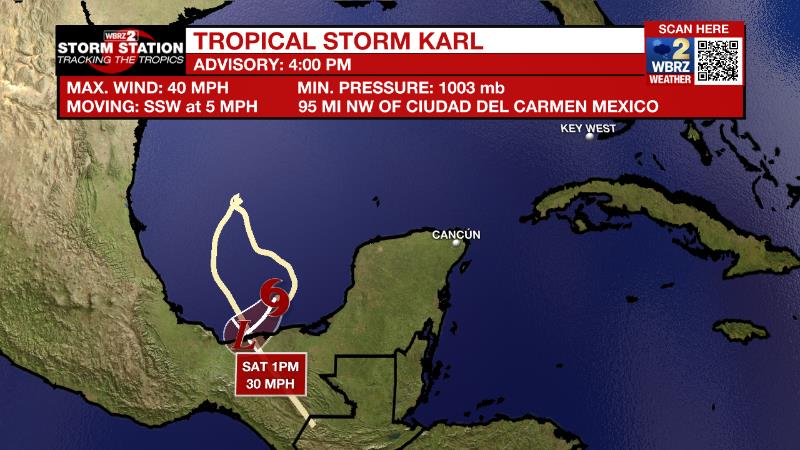
The Tropics: As of Friday afternoon, Tropical Storm Karl was over the Bay of Campeche moving south at 5mph with maximum sustained winds of 40mph. Little additional strengthening is expected before the storm makes landfall in Mexico on Saturday. Heavy rain may lead to flash flooding and mudslides there.
Trending News
The Explanation: As a surface high pressure system moves east onshore flow will increase through Saturday. Southeast winds will cause dew point temperatures and overall moisture to build into the region. A weak upper level ridge of high pressure will counteract the moisture to keep skies mainly clear. As a result, diurnal temperatures ranges will remain large with low temperatures in the mid to upper 50s and high temperatures in the upper 80s. A very strong upper level trough of low pressure will build into the Eastern U.S. on Sunday sending a cold front into the local area on Monday. Moisture will steadily increase through the atmosphere and therefore as the front moves in on Monday, broad lift will lead to mostly cloudy skies and a few showers. The front will fully sweep the area by Monday night with a much drier and colder air mass taking over. Northerly winds will keep chilly air streaming in through Thursday. Despite mainly clear and sunny afternoons, high temperatures will struggle to climb out of the 60s Tuesday and Wednesday. Overnight lows will fall into the 40s for most with upper 30s even possible in cooler rural areas, especially north and east of Baton Rouge. Widespread frost will be possible both of these nights.
--Josh
The Storm Station is here for you, on every platform. Your weather updates can be found on News 2, wbrz.com, and the WBRZ WX App on your Apple or Android device. Follow WBRZ Weather on Facebook and Twitter for even more weather updates while you are on the go.
More News
