

Latest Weather Blog
Friday PM Forecast: less active weather pattern as tropical moisture moves west
We will finally get a chance to have some less active weather later this weekend into early next week. The heat will increase a bit with fewer showers and thunderstorms around.
Next 24 Hours: Look for showers and thunderstorms to wrap up in the evening. Low temperatures will dip into the low 70s. A weather pattern transition will be underway on Saturday. Partly sunny skies will result in high temperatures in the low 90s. Scattered showers and thunderstorms will develop in the afternoon but there will likely be more activity closer to the coast and less farther inland toward the state line. In addition, the threat for street and poor drainage flooding will be lower.
10-30% - Isolated: a few locations receive measurable rain
30-60% - Scattered: part to half of the area receives measurable rain
60-100% - Widespread: almost all of the area receives measurable rain
Keep in mind, those chances tell nothing about timing. For instance, 100% DOES NOT mean it will rain all day. We will be sure to provide information in our forecasts as to when you can expect rain when chances are on the board. MORE: https://www.wbrz.com/news/a-chance-to-remember
Up Next: By Sunday, a slightly drier air mass will move into the region. While this will not eliminate activity, it will cause showers and thunderstorms to be more isolated in coverage and replace the heavy rain threat with a chance for gusty wind. If we could find one day in quite a while where most forecast area backyards stay dry, it would be Monday. Of course, drier days are hotter days. All signs point to a very tropical air mass returning for the middle and end of next resulting in another increase in rain coverage. CLICK HERE for your detailed 7-Day Forecast.
Trending News
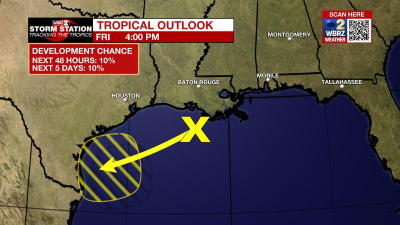
The Tropics: The surface trough of low pressure partly responsible for the last several days of heavy rain is trying to organize over the north-central Gulf of Mexico just offshore of southeastern Louisiana. There is just a ten percent chance of development for this system as it drifts west-southwestward over the northwestern Gulf of Mexico.
The Explanation: An upper level ridge of high pressure over the Mountain West will slowly nudge into our region over the weekend, pushing a decaying front toward I-10. While we may not feel any changes from the front in terms of heat or humidity, we will see a different type of weather pattern. Aloft, drier air is expected to filter into the area slowly. Therefore, Saturday will be transitional in that there should still be enough moisture for scattered showers and thunderstorms, especially south of the state line, but the risk for localized flooding will be lower. Sunday, measurable rain coverage will be even lower with showers and storms in their normal thirty percent distribution in the afternoon. Of course, as we see less development of clouds and precipitation, high temperatures will creep up a bit with more areas getting into the lower 90s, and for longer, on Sunday. The slightly drier trend will hold through Monday and possibly Tuesday. The ridge will retreat to the northwest by Wednesday and for the rest of next week tropical moisture will surge back with increasing rain daily coverage.
--Josh
The Storm Station is here for you, on every platform. Your weather updates can be found on News 2, wbrz.com, and the WBRZ WX App on your Apple or Android device. Follow WBRZ Weather on Facebook and Twitter for even more weather updates while you are on the go.
More News
