Friday AM Forecast: Today heat continues with a few sneaky showers
Sneaky showers this afternoon, but most people will feel more heat.
THE FORECAST
Today & Tonight: Starting off this Friday morning muggy. There is a thick layer of cloud cover locking in the heat and humidity to start the day. Temperatures now in the upper-70s and by the afternoon we will continue to watch them climb into the mid-90s. Not everyone will see rain, but if you do, you will be feeling a whole lot cooler than those that stay completely dry. Showers today will be spotty. Isolated areas could see downpours, it’s all dependent on when and where showers develop. Overnight, more clouds will move in and your Saturday will start the same.
Up Next: Southerly winds will lock in our forecast day after day. Saturday will start with temperatures in the upper-70s and cloudy skies. By the afternoon, clouds will be around the area and sneaky showers will begin to develop. Daytime highs for parts of the area will hit the mid-90s, but those that see showers early will stay a bit cooler. By Sunday we are expecting some slight changes to the pattern. Daytime highs will top out in the low-90s, but feels like temperatures will still manage to reach triple-digit heat. Showers will be more frequent during the afternoon hours. There will still be plenty of dry time during the day, but this is just your early heads up. If you have outdoor afternoon plans, you should have indoor back-up plans. Click here to see the 7-day forecast.
The Storm Station has you covered with hour-by-hour weather tracking is available for your location on the WBRZ WX App on your Apple or Android device. Follow WBRZ Weather on Facebook and Twitter for even more weather updates and unique weather insight from the whole team!
In the Tropics:
Trending News
The Atlantic basin is quiet for now. There are currently no spots that we are monitoring for further development.

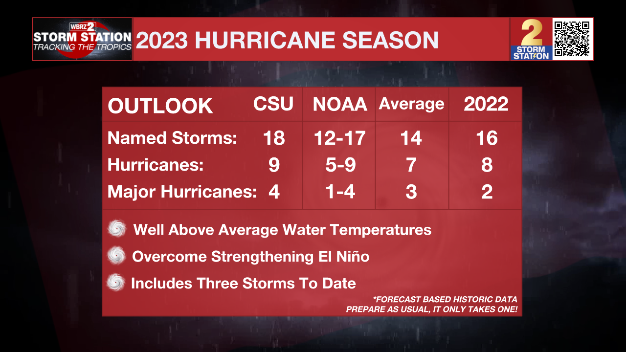
On Thursday, the major research outfit at Colorado State University updated their hurricane season outlook. All of the numbers have been given a bump up, even including the three systems that have formed so far. The experts attribute the above average outlook to extremely warm water temperatures overcoming the strengthening El Niño, which typically curtails the number of storms that form.


