

Latest Weather Blog
Clouding up ahead of the next storm
The weather pattern will begin to transition on Tuesday. However, organized rain should stay away until Thursday.
THE FORECAST:
Today and Tonight: Surface high pressure moving into the southeast U.S. will allow more clouds to work into the area on Tuesday. Some breaks of sun are possible. Southeast wind flow off the Gulf will hold highs in the low 80s despite the added cloud cover. Overnight will be mostly cloudy with lows in the low 60s.
Up Next: A low pressure and cold front will move in from the west late Wednesday, bringing a return of showers and thunderstorms through the latter half of the workweek. Storm activity will peak Thursday afternoon and a few storms could be strong. Some lingering activity is possible on Friday. The storm system will push east into southern Alabama and Georgia on Friday evening, allowing clouds to break up through the night. Sunny skies and slightly above average temperatures will return for the upcoming weekend. Highs will be in the low-to-mid 80s with lows in the low 60s.
The Mississippi River: At Baton Rouge, major flood stage continues with a level of 40.7’ as of Tuesday morning. Peaking at 44.1’ on March 19, the river set its 7th highest recorded crest at Baton Rouge. In addition, at 108 days this is now the 3rd longest period above flood stage. River flooding and drainage north of the area will keep the river steady over the next several days. The high water is primarily an issue for river traffic and river islands, although some inundation will continue unprotected low-lying areas. The city of Baton Rouge and the main LSU campus are protected by levees up to 47 feet. Some soggy areas and seepage may be noted due to the long duration of high water placing pressure on the levees. As some of the Mississippi River diverts into the Atchafalaya River, gauges at Krotz Springs and Morgan City will stay high as well. This creates backwater flooding in parts of Assumption Parish in areas such as Stephensville and around Lake Palourde. Like Big Muddy, this is expected to be a prolonged event but is not uncommon for the time of year. Read more HERE.
THE EXPLANATION:
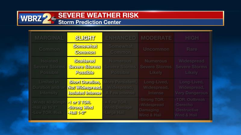
The axis of an upper level ridge will bounce east on Tuesday and therefore mid to upper level moisture will pass over the area resulting in more cirrus cloud development. Transitional weather will continue on Wednesday with similar skies and temperatures. An upper-level low will move into the region on Thursday. At the surface, a cold front will move from Texas into the local area. A moist airmass should be in place ahead of the front with dewpoints in the upper 60s. As a result, instability is forecast to develop along and ahead of the front from southern Louisiana into southern Mississippi. Thunderstorms will likely be ongoing along the front on Thursday morning with this convection moving eastward into the Baton Rouge area during the late morning and early afternoon hours. Forecast models agree on this timing. Enough wind shear and instability should be available for a few severe thunderstorms. An isolated tornado threat along with potential for wind damage and hail would exist with the stronger cells. Given the position of the front and parallel orientation of upper level winds, a squall line should develop during the afternoon. The Storm Prediction Center as placed the entire 13 Parish, 3 County forecast area in a 2 out of 5, “slight risk” for severe weather.
Trending News
An upper level trough will linger over the area on Friday allowing enough instability for some showers and thunderstorms to develop due to daytime warming. A clear, mild weekend will follow, but it will not be as cool behind that front as this past one.
--Josh
The WBRZ Weather Team is here for you, on every platform. Your weather updates can be found on News 2, wbrz.com, and the WBRZ WX App. on Apple and Android devices. Follow WBRZ Weather on Facebook and Twitter for even more weather updates while you are on the go.
More News
