

Latest Weather Blog
Baton Rouge area hot and humid as Florida prepares for Hurricane Matthew
The next cold front will arrive this weekend. Impacts from Hurricane Matthew are expected in the Southeastern United States as early as Thursday.
THE FORECAST:
Today and Tonight: Once again, the afternoon hours will feature mostly sunny skies with only an outside shot at a shower. Much of the summer’s rain has been evaporated or saturated deeply into the soil and thus continued sprinkling of the fall lawns is advised with no organized rain expected for a while. Wednesday’s high temperature will top out in the upper 80s. Overnight will be mostly clear with a low in the upper 60s.
Up Next: Thursday and Friday will be mostly sunny and warm with high temperatures near 90 degrees and low temperatures in the upper 60s. We’ll likely feel some humidity; however it shouldn’t be to the summer level. Another cold front will pass the area Saturday, dropping highs in the low and mid 80s with Sunday and Monday Morning lows in the upper 50s.
Trending News
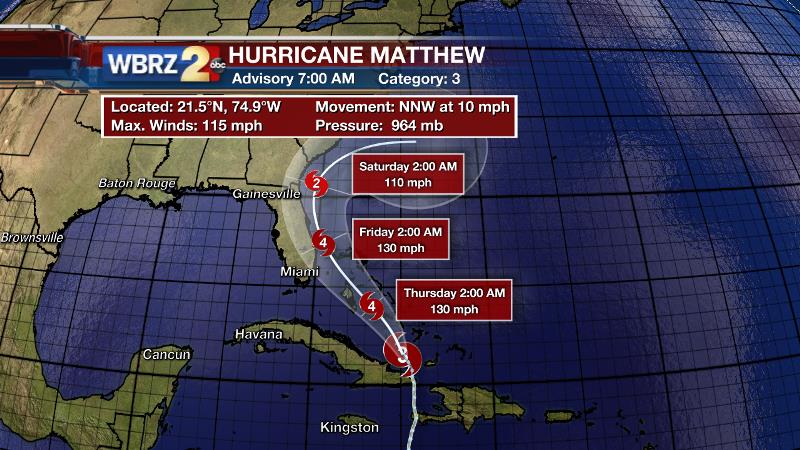
The Tropics: On Tuesday, Hurricane Matthew made landfall first in Haiti and then Cuba. Now attention shifts to The Bahamas and Florida where hurricane preparation is underway. As of 7am Wednesday, Hurricane Matthew remained a powerful category three storm packing winds of 115mph with a minimum central pressure of 964mb. Moving north, northwest at 10mph, a shift to the northwest and some strengthening are expected later today. Hurricane Warnings have been issued for The Bahamas and from Golden Beach to Sebastian Inlet, Florida. For those locations, conditions will deteriorate through Wednesday and Thursday. The official National Hurricane Center forecast cone brings the center of the storm very close to the Florida, Georgia and South Carolina Coasts. The cone accounts for the center of the storm; so it is important to note that effects can be felt dozens of miles from the center of the storm. Any slight shift in track, which is common, can have drastic changes on the weather. Hurricane Matthew could have an impact on Gainesville prior to the LSU and Florida football game on Saturday Afternoon. The latest information suggests tropical storm conditions are possible in Gainesville on Friday with winds in excess of 39mph and pockets of heavy rain. The key issue for with regard to the game, will be if and how extensive any power outages may be. As of 1pm Tuesday, the University of Florida said that there will be no changes to the game. In fact, by game time, the forecast calls for partly sunny skies and a temperature in the mid 80s. Greater than football, there are certainly concerns for life and property all along the Southeast Coast. Residents are advised to review hurricane preparedness plans put into place at the beginning of the season, and to monitor the latest advisories from the National Hurricane Center. The WBRZ Weather Team provides those advisories, as soon as they are issued on FACEBOOK and TWITTER. In addition, those in the forecast path of the storm should know if they are in an evacuation zone and take recommendations from local authorities. If you know somebody currently or planning a vacation on the East Coast, you might consider contacting them to alter plans. Matthew is not expected to impact Baton Rouge area weather in any way.
THE SCIENCE:
Forecast Discussion: The near term forecast is straightforward as an upper level trough moves into the Western United States with zonal flow persisting locally. Fairly dry air aloft will make it difficult for any kind of widespread showers and thunderstorms to develop. However with any ripples of energy aloft, there may be just enough surface instability to pop a low topped shower or two. The upper level trough will lift into the Great Lakes Region by the weekend advancing another cold front into the area. Like last week, this one will pass dry. There is actually a surprising amount of disagreement amongst the forecast models with regard to this front. The GFS model brings the front through on Saturday and has a stronger push of cool air. The European model is delayed and brings the front through on Sunday with much less of a temperature drop. With this feature, the GFS model has been more consistent and has support from other models and thus we’re favoring that solution at this point. Both agree that the front passes dry. Now if only it could speed up and push Hurricane Matthew out to sea…
You can stay in touch with Meteorologist Josh Eachus on FACEBOOK and TWITTER.
More News
