Thursday evening video forecast
Related Story
After one more chilly night, temperatures will quickly moderate on Friday afternoon. A few showers may get into the mix this weekend, but most of the time will be dry.
Next 24 Hours: Mainly clear skies and light winds through must of the night will send low temperatures tumbling into the low to mid 40s. The weather will stay quiet on Friday. However, an onshore wind shift during the afternoon will help to warm temperatures back above average into the low 70s. Added moisture will aid in increasing clouds as well.
Up Next: The weekend will start in the 60s before highs surge into the upper 70s. A weak front will press into the area from the northwest on Saturday, but this one looks rather lackluster. At the very least, there will be some additional cloudiness and perhaps some isolated showers or a thunderstorm. Much of the day will be dry. Clouds and a spotty shower will be possible on Sunday too as the front falls apart over the local area. Thermometers will stay 10-15 degrees above average Sunday through Thursday before the next front arrives by the middle of next week. CLICK HERE for your detailed 7-Day Forecast.
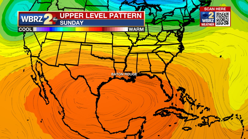
The Explanation: An upper level trough of low pressure will move across the High Plains Friday, crossing the Mississippi River well to our north on Friday night. As a surface high pressure system slides east, southeasterly flow will return and bring moisture back to the area. This low level moisture will cause clouds to thicken and be the dominate feature in skies over the weekend. On Saturday, the associated cold front will approach during the afternoon hours. Due to ongoing surface warming, there may be just enough instability for isolated showers and rumbles of thunder. Coverage will be thin across the forecast area with the best chance in southwest Mississippi. As the front stalls and fall apart between the I-10/12 corridor and Gulf of Mexico on Sunday, a spotty shower will still be possible.

Early next week, a broad upper level ridge of high pressure will center over the Gulf of Mexico. Since warmth and moisture never gets removed by the weakening cold front, mostly cloudy skies and unseasonably warm temperatures will continue. Highs will be topping out in the upper 70s to the low 80s. Records this time of year run around the low to mid 80s, so we won't be too far off from that.
--Josh
The Storm Station is here for you, on every platform. Your weather updates can be found on News 2, wbrz.com, and the WBRZ WX App on your Apple or Android device. Follow WBRZ Weather on Facebook and Twitter for even more weather updates while you are on the go.


