

Latest Weather Blog
Sunday Morning Forecast
Related Story
Plenty of sunshine before the showers today.
THE FORECAST
Today & Tonight: A sunny start for your Sunday. Mostly sunny skies will stick around until cloud cover starts building in around lunch time. With mostly sunny skies temperatures will heat into the high-80s low-90s across the area. Afternoon showers are going to come in and cool us off a bit. Not expecting a total washout this afternoon. Showers and storms will wrap up across the area quickly before any evening plans. Overnight temperatures are going to cool back into the mid-70s and the rainy pattern is set on repeat for your workweek.
Up Next: Not expecting very much change in the forecast for your workweek. Waking up Monday morning to mostly sunny skies and temperatures in the mid-70s. Throughout the day temperatures will creep into the low-90s. Plenty of moisture will allow for heat index values to reach the triple digits during the peak daytime heat hours. Showers and cloud cover will begin to build into the area as the day goes on. The rainy pattern will stick around for the workweek. Waking up to temperatures in the mid-70s. Daytime highs will top out in the low-90s with showers bubbling up during the afternoon hours. Overnight temperatures will cool back into the 70s. Localized areas could see heavy downpours and some poor street and drainage flooding after repeated rounds of rain. Click here to see the 7-day forecast.
Hour-by-hour weather tracking is available for your location on the WBRZ WX App on your Apple or Android device. Follow WBRZ Weather on Facebook and Twitter for even more weather updates and unique weather insight from the whole team!
In the Tropics:
As of now we are not tracking any direct threats to the Gulf coast. Until cyclone formation, models are highly uncertain if/when and where systems will develop.
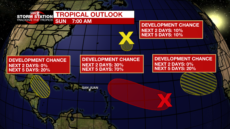
Central Tropical Atlantic:
A broad and elongated area of low pressure is located over the
central tropical Atlantic Ocean. Although the associated shower
and thunderstorm activity has increased somewhat since yesterday,
it currently lacks organization. Environmental conditions are
expected to be generally conducive for gradual development, and a
tropical depression is likely to form later this week while moving
toward the west and then west-northwest at around 10 mph, toward the
waters east of the Leeward Islands.
* Formation chance through 48 hours...low...30 percent.
* Formation chance through 5 days...high...70 percent.
Central Atlantic:
A small low pressure system located about 600 miles east of Bermuda
continues to produce occasional, disorganized shower activity.
Strong upper-level winds and dry air are expected to limit
significant development of this system while it meanders over the
central Atlantic during the next few days, and the low is likely to
dissipate by midweek.
* Formation chance through 48 hours...low...10 percent.
* Formation chance through 5 days...low...10 percent.
Northwestern Caribbean Sea:
A trough of low pressure could develop over the northwestern
Caribbean Sea during the middle part of this week. Environmental
conditions could support some slow development of the system
thereafter while it moves generally west-northwestward over the
northwestern Caribbean Sea and toward the Yucatan Peninsula of
Mexico.
* Formation chance through 48 hours...low...near 0 percent.
* Formation chance through 5 days...low...20 percent.
Eastern Tropical Atlantic:
A tropical wave is forecast to move off the west coast of Africa
Monday or Monday night. Some gradual development of the system is
possible after that time while it moves generally westward across
the far eastern tropical Atlantic.
* Formation chance through 48 hours...low...near 0 percent.
* Formation chance through 5 days...low...20 percent.
News
