

Latest Weather Blog
Monday Afternoon Forecast
Related Story
Threat for severe weather tomorrow morning, stay connected with the Storm Station so that you can be prepared.
THE FORECAST
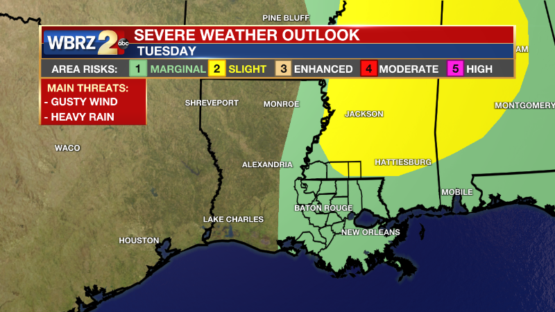
Tonight & Tomorrow: Today will be our last day with unseasonably warm temperatures this week. Overnight more cloud cover will build in as a cold front approaches the area, but not expecting any rain just yet. Once the front starts pushing into the Capital Area we will start to see some showers and storms. Some of the storms will have the potential to become severe with gusty winds above 60mph and heavy rain. All of the viewing area is under a severe weather outlook from a level 1/5 Marginal to a level 2/5 Slight risk for severe storms. Stay connected with the Storm Station and be sure to have the most up to date information before you leave Tuesday morning.
By lunchtime, this front will be well out of the area and all we will be left with is completely clear skies. Into the afternoon hours temperatures will still have plenty of time to heat into the high-70s. Northwesterly winds will continue to bring cooler, drier weather in. Overnight we will see the impacts of the cold front with lows back in the 50s.
Up Next: For the middle of your workweek, the forecast will be pleasant. Starting Wednesday morning you will wake up to temperatures in the low-50s and sunny skies. Daytime highs will be just below average in the mid-70s. Our next chance for rain will come in on Friday into the weekend. We are not tracking any total washouts. Click here to see the 7-day forecast.
Quick cold front moving through, do not let sneaky showers catch you off guard. The Storm Station has you covered with hour-by-hour weather tracking is available for your location on the WBRZ WX App on your Apple or Android device. Follow WBRZ Weather on Facebook and Twitter for even more weather updates and unique weather insight from the whole team!
In the Tropics:
Areas of potential development will not impact the local viewing area.
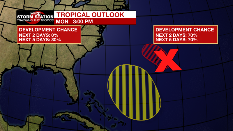
Central Subtropical Atlantic:
Satellite and Bermuda radar images indicate that the low pressure
system located about 100 miles east-southeast of Bermuda now has a
well-defined center and is producing a relatively concentrated area
of showers and thunderstorms. If the thunderstorm activity
persists near the center, the disturbance will likely become
a tropical depression later today or tonight while it moves
west-northwestward and passes near Bermuda. After that time, the
system is expected to turn northward and move toward cooler waters
and into a region of unfavorable upper-level winds, which should
limit additional development. Regardless of development, periods
of locally heavy rainfall and gusty winds are expected over Bermuda
through tonight. Interests in Bermuda should monitor the progress
of this system.
* Formation chance through 48 hours...high...70 percent.
* Formation chance through 5 days...high...70 percent.
Southwestern Atlantic:
An area of low pressure is expected to form north of Puerto
Rico over the southwestern Atlantic in a few days. Thereafter,
environmental conditions appear conducive for gradual subtropical
development of this system while it meanders over the southwestern
Atlantic through the early part of the weekend.
* Formation chance through 48 hours...low...near 0 percent.
* Formation chance through 5 days...low...30 percent.
News
