

Latest Weather Blog
Wednesday AM Forecast: Tropics are heating up for the official start of hurricane season, No local impacts expected
June 1st marks the first official day of the Atlantic Hurricane Season. Stick with the Storm Station as we track the tropics around the clock.
THE FORECAST
Today & Tonight: Temperatures are set to climb into the low 90s with the heat index neat 96° this afternoon. A few showers will bubble up to cool things off. A pop-up shower could bring a brief heavy downpour, gusty winds, and frequent lightning. Not everyone will see rain, and showers that do pop up will be short-lived. Temperatures will be ion the low 70s tonight.
Use the WBRZ WX App to keep tabs on afternoon pop-up showers. Hour-by-hour weather tracking is available for your location on the WBRZ WX App on your Apple or Android device. Follow WBRZ Weather on Facebook and Twitter for even more weather updates and unique weather insight from the whole team!
Up Next: The regular summertime humidity will stick around through the week with a few showers each day. We are not tracking any total washouts. If you have outdoor plans in the afternoon, keep an eye on the radar, so you aren’t caught off guard. Showers will bubble up quickly and move out quickly too. On Thursday the bulk of the showers will hold off until after sunset. A weak boundary will be the rainmaker on Thursday evening into Friday. Showers and storms could bring a brief heavy downpour, gusty winds, and frequent lightning. Friday morning will be clear, but more showers are possible in the afternoon. Isolated showers are possible into the weekend too. Click here to see the 7-day forecast.
In the Tropics:
Trending News
The remnants of Agatha have a 80% chance of redeveloping in the southern Gulf of Mexico later this week. Regardless of development, this system is going to be a major rainmaker for the Yucatan Peninsula, parts of Cuba, and south Florida. It will move northeast and it is not expected to impact the local forecast. There is an additional disturbance on the east side of Florida with a 10% chance of developing. That system is also moving northeast away from the local area. CLICK HERE to watch the tropical video forecast.
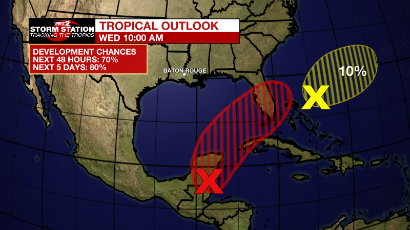
Near the Yucatan Peninsula and Southeastern Gulf of Mexico: A large area of disorganized showers and thunderstorms located over the northwestern Caribbean Sea and Yucatan Peninsula is associated with a broad area of low pressure. Environmental conditions appear conducive for gradual development, and this system is likely to become a tropical depression while it moves northeastward over the northwestern Caribbean Sea and southeastern Gulf of Mexico during the next couple of days. Regardless of development, locally heavy rainfall is likely across portions of southeastern Mexico, the Yucatan Peninsula, and Belize during the next day or so, spreading across western Cuba, South Florida, and the Florida Keys on Friday and Saturday. Interests in the Yucatan Peninsula, western Cuba, the Florida Keys, and the Florida Peninsula should monitor the progress of this system.
* Formation chance through 48 hours...high...70 percent.
* Formation chance through 5 days...high...80 percent.
Southwestern Atlantic northeast of the Bahamas:
A weak surface trough located around 200 miles northeast of the central Bahamas is producing disorganized shower activity as it interacts with an upper-level trough. Surface pressures are currently high across the area, and significant development of this system appears unlikely as it moves generally east-northeastward over the next several days away from the southeastern United States.
* Formation chance through 48 hours...low...10 percent.
* Formation chance through 5 days...low...10 percent.
.png)
More News
