

Latest Weather Blog
Thursday PM Forecast: showers possible to start the weekend
A storm system will bring a 12 to 18 period when showers and thunderstorms will be possible late Friday into Saturday. Drier weather is expected for the second half of the weekend.
Next 24 Hours: Another mainly clear and quiet night is ahead. Low temperatures will bottom out in the low 50s with calm winds. A developing storm system over Texas will spread clouds into the area through Friday. High temperatures will not warm much more than the mid 70s as clouds cut off sunshine. By later afternoon and early evening, showers will push in from west to east. Some high school football games could turn out to be damp. A cold front will continue to bring showers and possibly a few thunderstorms to the area overnight.
Up Next: Until a weakening cold front passes through, scattered showers and thunderstorms will be possible on Saturday morning. While not a big threat at this time, there is an outside shot for one or two strong storms—especially closer to the coast. Rainfall totals will range from about a half inch to one inch—not drought busting but potentially helpful. The area will dry out from west to east Saturday, but at least some clouds could linger into Sunday. Temperatures will remain closer to average beyond that system into early next week. Dry weather is anticipated for Halloween and trick-or-treating. CLICK HERE for your detailed 7-Day Forecast.
#Halloween sits on a quieter part of the weather calendar in the #BatonRouge Area. Here is the early call for this edition and notes on some "trickier" years in the past ?? https://t.co/tl5UhdJXUb
— Josh Eachus (@DrJoshWX) October 27, 2022
Trending News
The Tropics: Recent satellite-derived wind data indicate a trough of low pressure extends over the southwestern Atlantic Ocean, and it continues to produce a broad area of disorganized showers and thunderstorms. A surface low pressure system is forecast to emerge along the northern portion of the trough axis tonight, and there is a forty percent chance that a subtropical depression could form during the next day or so while the system moves northward over the western Atlantic. By late Saturday, upper-level winds are forecast to become less conducive for development, and the low is expected to begin interacting with an approaching frontal system.
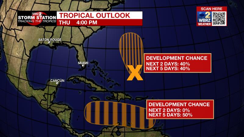
An area of low pressure is expected to form over the eastern Caribbean Sea this weekend, possibly related to the southern portion of an existing trough of low pressure over the area. Environmental conditions are forecast to be conducive for gradual development, and there is a fifty percent chance that a tropical depression could form early next week while the disturbance moves generally westward or west-northwestward over the central Caribbean Sea.
The Explanation: An upper level trough of low pressure over the Mountain West will move eastward on Friday causing the jet stream to come out of the southwest and increase moisture over the local area. Expect an increase in high clouds early in the day and that deck will lower and thicken into the afternoon. Since onshore winds will not strengthen until afternoon, the atmosphere will not be saturated enough for light rain to develop until later in the day. The upper level trough will then track out of Texas into Louisiana Friday night into Saturday. The associated surface low will move from southeast Texas across the I-10/12 corridor during that same time period. Moisture will surge well above average as this occurs, supporting scattered to widespread precipitation. The question is exactly how far inland will warmer surface air surge and therefore allow thunderstorms? At this time, it looks as though the most unstable air will remain near the coast resulting in only some rumbles of thunder in and around Baton Rouge. However, any northward jog in that instability could open the door for one or two strong thunderstorms on Saturday morning. Drier air will push in by Saturday afternoon ending precipitation from west to east. A few low level clouds may linger Saturday night into Sunday. For Halloween and early next week, a weak surface high pressure system in the region will dictate quiet weather with near average temperatures. A weak system well to our south could throw a shower or two inland Tuesday night or Wednesday morning.
--Josh
The Storm Station is here for you, on every platform. Your weather updates can be found on News 2, wbrz.com, and the WBRZ WX App on your Apple or Android device. Follow WBRZ Weather on Facebook and Twitter for even more weather updates while you are on the go.
More News
