

Latest Weather Blog
Thursday PM Forecast: more cool mornings, gradual warming starts Saturday
Pleasant weather will continue into the weekend. Temperatures will gradually moderate Saturday through the middle of next week.
Next 24 Hours: Another clear and cool night is ahead. With light, northeast winds, lows will bottom out in the mid 50s. On Friday, highs will stride for 80 degrees with continued northeast breezes. Skies will stay mainly sunny but a few cirrus clouds could get into the mix.
The nice weather will follow #BatonRouge area CFB Teams into Mississippi this weekend. ?? ?? #GeauxTigers #GeauxJags pic.twitter.com/JRjfuCvVAy
— Josh Eachus (@DrJoshWX) September 23, 2021
The comfortable conditions will not be reserved for just Baton Rouge. LSU and Southern fans traveling into Mississippi will continue to enjoy sunshine and low humidity. In Starkville, the Tigers will kick off to a temperature of 74 degrees, climbing into the upper 70s by afternoon. Outside of Jackson, thermometers will be a little warmer as the Jags start near the warmest part of the day.
Trending News
Up Next: Saturday will offer one final morning that is likely to start in the 50s for most. With mostly sunny skies, readings will top out in the low 80s during the mid-afternoon. By Sunday, winds will start to shift east or even southeast and thermometers will more noticeably moderate, but remain beneath seasonal averages in the upper 80s and upper 60s. Some clouds may begin to build into the area but rain does not reenter the forecast until Tuesday and even then, only isolated activity is expected. The best chance for some garden-variety showers and thunderstorms will be Wednesday. Overall, no significant weather impacts are anticipated through the end of next week. CLICK HERE for your full 7-Day Forecast.
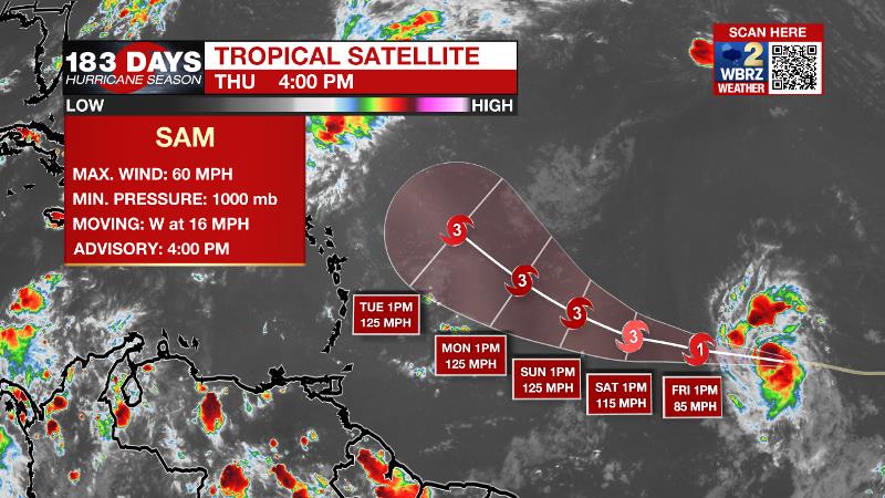
The Tropics: Tropical Storm Sam continues to strengthen and will likely undergo rapid intensification over the next few days. Moving west-northwest over the central Atlantic Ocean, Sam could be a major hurricane northeast of the Lesser Antilles on Saturday. At this time, it is forecast to remain out to sea. The remnants of Odette have a 60 percent chance of becoming a subtropical storm over the North Atlantic before conditions become too hostile over the weekend. A surface trough of low pressure southeast of Bermuda has a 10 percent chance of development before the weekend. The next tropical wave rolling off the African Coast has a 30 percent chance of development over the next 5 days. For the latest tropical forecasts, advisories and information, visit the WBRZ Hurricane Center as we navigate all 183 Days of Hurricane Season.
The Explanation: With clear skies and light winds, optimal conditions will be in place for overnight cooling. Therefore, a second straight morning of low temperatures in the mid, to perhaps low 50s is anticipated. Surface high pressure will remain anchored over the Mid-Mississippi River Valley on Friday with a continuation of light northeasterly winds as a result. A few mid to high clouds could show up in otherwise mainly clear skies. These conditions will repeat on Saturday. An upper level ridge will start to build overhead on Sunday and this will initiate a gradual climb in high and low temperatures beginning with our first morning out of the 50s on Sunday followed by an afternoon well into the 80s. Into next week, the surface high will shift far enough east to change local wind flow to the southeast beginning a return of moisture. Meanwhile, a weakening upper level trough of low pressure pinching into the Southeast will allow a weak front to setup in the region. While the entire atmosphere may be slow to have enough moisture recovery, it is plausible that isolated showers could develop Tuesday through the end of next week, especially south and west of Baton Rouge.
--Josh
The WBRZ Weather Team is here for you, on every platform. Your weather updates can be found on News 2, wbrz.com, and the WBRZ WX App on your Apple or Android device. Follow WBRZ Weather on Facebook and Twitter for even more weather updates while you are on the go.
More News
