

Latest Weather Blog
Thursday PM Forecast: heat and humidity prevail through weekend
Hot air and high humidity will make for an uncomfortable run of days. Rain may not be entirely absent but is far less likely than the last few days.
Next 24 Hours: Showers will quickly diminish after sunset followed by clearing skies. Low temperatures will struggle to drop into the mid 70s. Heat will become the big weather story Friday. High temperatures will swell into the low to mid 90s. However, ample humidity will create a heat index, or feels-like temperature over 100 degrees for several hours. The search for a cooling shower will be fruitless for most.
A HEAT ADVISORY is in effect from 9am – 7pm Friday. An EXCESSIVE HEAT WATCH is in effect for Saturday. The heat-index, or feels-like temperatures, could be higher than 108 degrees, especially Saturday. Be prepared to drink plenty of fluids, stay in an air- conditioned room, stay out of the sun, and check up on relatives and neighbors. Young children and pets should never be left unattended in vehicles under any circumstances. This is especially true during warm or hot weather when car interiors can reach lethal temperatures in a matter of minutes.
Up Next: An upper level ridge of high pressure will park over the central Gulf Coast through Monday. This system will cause slightly drier and warmer weather. Through Monday, rain coverage in the 13 Parish, 3 County Forecast Area will stay at 10 percent or less—and that may be generous. Highs will reach the mid 90s with feels-like temperatures possibly exceeding 105 degrees for several hours each day. Lows will stay in the mid to upper 70s. Expect ongoing HEAT ALERTS from the National Weather Service. CLICK HERE for your full 7-Day Forecast.
Trending News
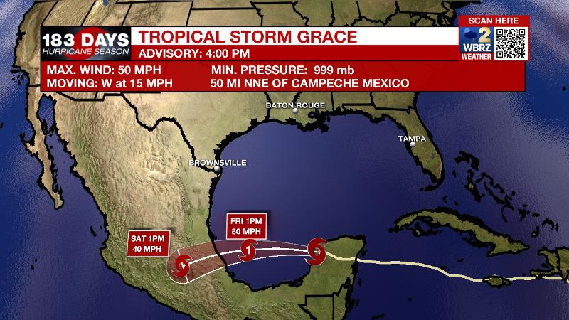
The Tropics: As of 4pm Thursday, Tropical Storm Grace was exiting the Yucatan Peninsula to the east. The storm had maximum sustained winds at 50mph, moving to the west at 15mph. This general motion or a more west-southwest track will occur over the next few days as Grace regains hurricane status and makes a second landfall in central Mexico Friday into Saturday.
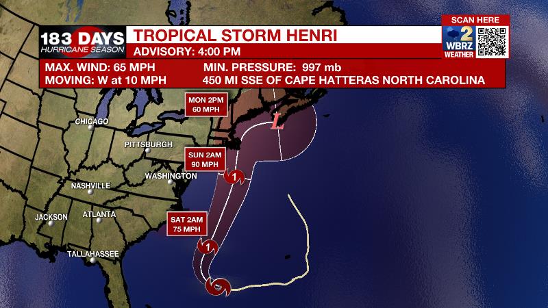
As of 4pm Thursday, Tropical Storm Henri was south of Bermuda with maximum sustained winds of 65mph and a west motion at 10mph. Henri will speed and strengthen into a hurricane while circling west of Bermuda. The newest track, takes Henri close and possibly into the Northeast U.S.
For the latest tropical forecasts, advisories and information, visit the WBRZ Hurricane Center as we navigate all 183 Days of Hurricane Season.
The Explanation: On Friday, an upper level ridge will build across the region. This system will cause subsidence, or sinking air, will serves to suppress convection and cause even more warming. With humidity not going anywhere, the heat index will have no problem reaching the 105 – 110 range Friday through Monday as air temperatures peak in the mid 90s. Expect the National Weather Service to issue Heat Advisories several days in a row. Friday and Saturday should feature a rather dry atmosphere and rain will be tough to find. A little bit more moisture may be found in the atmosphere on Sunday and Monday for isolated, afternoon showers and thunderstorms to develop. The bottom line is, it is difficult to guarantee completely dry conditions across the area with all the instability along the Gulf Coast this time of year, but daily rain coverage will be much lower than usual.
--Josh
The WBRZ Weather Team is here for you, on every platform. Your weather updates can be found on News 2, wbrz.com, and the WBRZ WX App on your Apple or Android device. Follow WBRZ Weather on Facebook and Twitter for even more weather updates while you are on the go.
More News
