

Latest Weather Blog
Thursday PM Forecast: football forecast and the next cold front
It seems so long ago that we were enjoying fall-like weather with dry conditions and low humidity. Many locations have picked up 2-4 inches of rain since Tuesday, with locally higher amounts.
Next 24 Hours: With the loss of daytime warming, rain coverage will fade overnight. Low temperatures will be muggy in the low 70s. On Friday, a slightly warmer atmosphere will cause showers and thunderstorms to be less numerous. Isolated, 30 percent coverage is expected across the 13 Parish, 3 County forecast area. Activity will also take a little later into the day to develop. High temperatures will therefore have a chance to warm into the mid 80s.
Up Next: There is no reason to believe the pattern will change on Saturday. Thermometers will take another run into the 80s with some breaks of sun. Those heading out to the LSU campus for game day festivities should pack an umbrella or a poncho as a precaution. While the day is not expected to be a washout, an afternoon shower or thunderstorm is possible. Deeper into the evening, rain chances will subside. Sunday and Monday will bring scattered showers and thunderstorms ahead of a cold front. That boundary should pass through the area by Tuesday to lower rain chances, temperatures and humidity for at least a few days next week. CLICK HERE for your full 7-Day Forecast.
Trending News
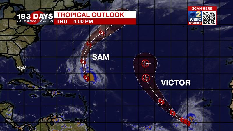
The Tropics: Category Four Hurricane Sam is expected to pass east of Bermuda. However, tropical storm conditions will be possible there as the storm holds its intensity while moving north over the next few days. Tropical Storm Victor will continue gradually strengthening through Friday while moving west-northwest over the eastern Atlantic. Weakening is expected after that. For the latest tropical forecasts, advisories and information, visit the WBRZ Hurricane Center as we navigate all 183 Days of Hurricane Season.
The Explanation: A weak upper level ridge will be the dominant feature on Friday and Saturday leading to a warmer, slightly more stable atmosphere and therefore reducing the number of showers and thunderstorms. Still, weak disturbances rolling through the upper levels will have plenty of moisture to work with so the wording of isolated showers and thunderstorms could “bust” on the low side either afternoon. As instability lessens into the evenings, the next few nights will by dry. Another upper level trough of low pressure will move east across the country on Sunday and start to break down the ridge. Scattered showers and thunderstorms will develop as this process occurs and instability increases throughout Sunday.
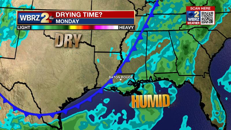
The trough will amplify and dig southeast on Monday and Tuesday pulling an associated surface cold front into and eventually through the area. While there are some timing differences, a drier air mass is expected to arrive sometime on Tuesday ending the unsettled, wet weather pattern and ushering in seasonable temperatures with lower humidity for the middle of next week. The upper level trough may close into an upper level low and park over the Southeast U.S. for a few days next week. This feature could maintain cloud cover and slightly cooler temperatures through at least Thursday.
--Josh
The WBRZ Weather Team is here for you, on every platform. Your weather updates can be found on News 2, wbrz.com, and the WBRZ WX App on your Apple or Android device. Follow WBRZ Weather on Facebook and Twitter for even more weather updates while you are on the go.
More News
