

Latest Weather Blog
Thursday PM Forecast: clearing, drier and cooler to end the week
The chance for strong thunderstorms ended on Thursday afternoon. Another pop of cool and dry air is in store for Friday and Saturday.
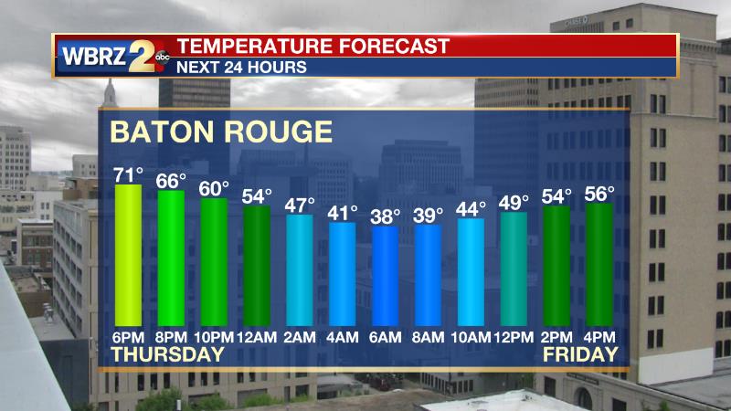
Next 24 Hours: A cold front will move east of the area tonight allowing rain to end early and skies to clear from west to east. Only a few clouds will linger after midnight. North winds of 10-15mph morning as low temperatures dip into the upper 30s. Expect mostly sunny skies on Friday afternoon, but ongoing cool, north winds will keep high temperatures in the mid 50s.
Up Next: Cooler temperatures will stick around into Saturday morning with low temperatures near freezing. Skies will be almost all clear in the afternoon as high temperatures chug back into the low 60s. Sunday will be transitional with some early sun helping temperatures back to average in the upper 60s but clouds will increase late. As moisture returns from the Gulf of Mexico due to southerly winds, periods of rain will break out on Monday. From there, warm afternoon temperatures and isolated to scattered showers will stay in the forecast through at least Thursday. CLICK HERE for your detailed 7-Day Forecast.
The Explanation: On Friday, upper level winds will setup in a zonal pattern—that is west to east—which is often indicative of quiet weather. A series of weak disturbances will move over the area, but thanks to the drier atmosphere left behind by the front, only some patchy clouds are expected. As the cold pool of air left in the wake of the front departs, temperatures will start to moderate from 10 degrees below average on Friday, to 5 degrees below average on Saturday to average by Sunday. However, since the atmosphere will remain dry, temperatures will cool into the low to mid 30s Friday and Saturday nights. By the end of the weekend, surface winds will shift back to the southeast allowing moisture to infiltrate the atmosphere. While the day is expected to remain dry, there should be a noticeable increase in clouds with skies turning overcast by Sunday night. Another upper level disturbance sliding in from the west will tap into the deeper moisture across the region and bring a swath of rain to the area on Sunday night and Monday. The atmosphere should remain too stable for strong thunderstorms, but some brief downpours will be possible. As that disturbance exits, and upper level ridge of high pressure will broaden across the Southeast. With that feature, continued onshore flow will leave plenty of moisture in place and allow warming temperatures through the middle of next week. High temperatures could be 10 to 15 degrees above average. A few upper level disturbances could work with a poorly defined surface boundary over the area to keep isolated to scattered showers around Tuesday through Thursday. While the periodic rain could be a nuisance, it may well be beneficial to the ongoing drought and fire conditions.
Trending News
--Josh
The Storm Station is here for you, on every platform. Your weather updates can be found on News 2, wbrz.com, and the WBRZ WX App on your Apple or Android device. Follow WBRZ Weather on Facebook and Twitter for even more weather updates while you are on the go.
More News
