

Latest Weather Blog
Thursday PM Forecast: another breezy day with stubborn clouds
Fall-like conditions certainly have arrived in the Capital City! Halloween weekend will remain cool but with less wind and clouds.
Next 24 Hours: Breezy conditions will continue overnight. Winds will be out of the northwest at 10-15mph. With a good bit of cloud cover persisting, low temperatures will stop in the low 50s. A few breaks of sun should be available on Friday, especially south of I-10. However, the stubborn low clouds and continuing northwest breeze of 5-10mph will keep high temperatures in the mid 60s.
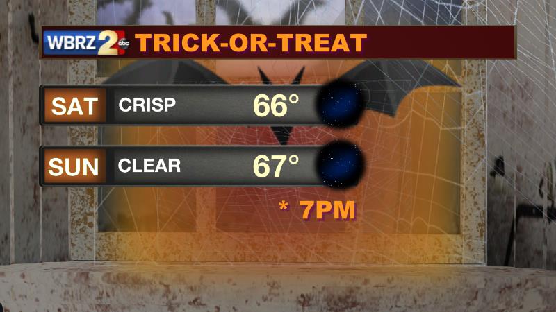
Up Next: Winds will subside into the weekend and as skies clear, Saturday morning low temperatures will dip into the upper 40s. Seasonable and pleasant conditions are in store through Halloween and right into early next week. Either weekend evening, trick-or-treaters will have clear skies and temperatures in the 60s. Monday and Tuesday will stay dry with highs moderating into the mid 70s and lows in the mid 50s. A weak cold front will try to return showers to the area by Thursday. CLICK HERE for your full 7-Day Forecast.
Trending News
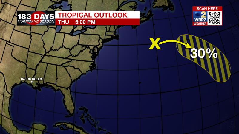
The Tropics: A non-tropical low pressure system southeast of Nova Scotia has a 30 percent chance of development as it drifts southeast over the central Atlantic over the weekend or early next week. As we move into late October, it is increasingly rare for tropical systems to strike Louisiana. In fact, with records dating back to the 1860s, only four storms have made landfall past October 20. For the latest tropical forecasts, advisories and information, visit the WBRZ Hurricane Center as we navigate all 183 Days of Hurricane Season.
The Explanation: Due to the steep pressure gradient caused by a strong upper level low pressure and associated surface storm system, winds will remain elevated well into the end of the week. Sustained winds of 10-20mph are possible on Friday with isolated higher gusts. These stiff winds will also continue to usher in much cooler and drier air. In fact, the coolest air will likely arrive Friday and Friday night as that system gets a bit farther east and winds turn more due north. The other consequence of the slow, deep upper level low is a persistent cloud deck wrapping around it and that will keep cloud cover in place until that eastward movement occurs. So, high temperatures on Friday are likely to stay in the low to mid 60s due to the combination of cooler air advancing in plus the stubborn clouds and then as skies clear Friday night, low temperatures will head for the upper 40s. Through Saturday and by Sunday, the whole complex will be far enough east for sunshine to return and winds to slacken. This will allow for a slow warming trend on Sunday with temperatures rebounding back up into the middle 70s on Sunday under clear skies. The weather will stay quiet through mid-week as a weak but broad surface high pressure system remains in place over the forecast area. The next upper level trough of low pressure will swing down through region by Thursday with a weak cold front that is likely to be starved of the favorable ingredients for stormy weather. Therefore, just some clouds and showers are anticipated at this time.
--Josh
The WBRZ Weather Team is here for you, on every platform. Your weather updates can be found on News 2, wbrz.com, and the WBRZ WX App on your Apple or Android device. Follow WBRZ Weather on Facebook and Twitter for even more weather updates while you are on the go.
More News
