

Latest Weather Blog
Thursday AM Forecast: Scattered showers locally, watching the tropics
It is Thursday and the pattern is set to repeat again.
THE FORECAST
Today & Tonight: Temperatures will be in the low 90s before a few showers bubble up this afternoon. A boundary is going to move through the area tonight bringing more scattered showers after sunset. Overnight temperatures will be in the low 70s.
Use the WBRZ WX App to keep tabs on afternoon pop-up showers. Hour-by-hour weather tracking is available for your location on the WBRZ WX App on your Apple or Android device. Follow WBRZ Weather on Facebook and Twitter for even more weather updates and unique weather insight from the whole team!
Up Next: The regular summertime humidity will stick around through the week with a few showers each day. We are not tracking any total washouts. If you have outdoor plans in the afternoon, keep an eye on the radar, so you aren’t caught off guard. Showers will bubble up quickly and move out quickly too. Showers and storms could bring a brief heavy downpour, gusty winds, and frequent lightning. Friday morning may have a few leftover showers, but the bulk of the rain coverage is forecast for the afternoon. You will have to dodge showers and storms over the weekend. Between the clouds, temperatures will be in the low 90s. Click here to see the 7-day forecast.
In the Tropics:
Trending News
A tropical disturbance in the northwest Caribbean has an 80% chance of developing in the next two days. Regardless of development, this system is going to be a major rainmaker for the Yucatan Peninsula, parts of Cuba, and south Florida. It will move northeast and it is not expected to impact the local forecast. CLICK HERE to watch the latest tropical forecast.
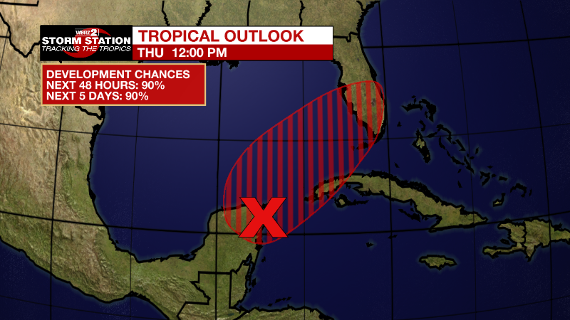
Near the Yucatan Peninsula and Southeastern Gulf of Mexico: A broad area of low pressure located near the east coast of the Yucatan Peninsula continues to produce a large area of disorganized showers and thunderstorms over the northwestern Caribbean Sea and Yucatan Peninsula. Despite strong upper-level winds, this system is likely to become a tropical depression or tropical storm while it moves slowly northeastward over the northwestern Caribbean Sea and southeastern Gulf of Mexico during the next day or two. Interests in western Cuba, the Florida Keys, and the Florida Peninsula should monitor the progress of this system, and tropical storm watches or warnings could be required for some of these areas later today. Regardless of development, areas of heavy rainfall are likely across portions of the Yucatan Peninsula and western Cuba during the next day or so, spreading across southern and central Florida and the Florida Keys Friday and Friday night, and the northwestern Bahamas on Saturday. These heavy rains could cause scattered to numerous flash floods across South Florida and the Florida Keys.
* Formation chance through 48 hours...high...90 percent.
* Formation chance through 5 days...high...90 percent.
More News
