

Latest Weather Blog
Sunday PM Forecast: Rainy pattern locked in for your Labor Day forecast
Labor Day holiday with rain in the forecast
THE FORECAST
Tonight & Tomorrow: The light rain will begin to fizzle out across the area as the sun starts to set. No heavy downpours recorded today but most people saw at least some light drizzle. Temperatures did not break the mid-80s today due to the amount of cloud cover. Overnight temperatures will cool into the low-70s. To start your Labor Day Monday, showers will be creeping into the Capital Area. Heavy downpours, gusty winds, and frequent lightning are a possibility as these storms move through the area. Shower activity will be heaviest in the late morning/early afternoon hours. Since it is a holiday, commuting traffic could be a bit of a mess. Temperatures will peak in the mid-80s due to cloudy skies and shower activity. Overnight clouds will linger and temperatures will fall back into the low-70s.
Up Next: Tuesday more of the same rainy pattern is expected. Partly sunny skies to start off your day with temperatures in the low-70s. During the day a break in cloud cover could allow temperatures to climb towards the high-80s. As temperatures heat up our chance for afternoon showers begins to increase. Showers and storms will be well out of the area by the evening hours. The pattern will stay locked in for your workweek. Muggy mornings with temperatures in the mid-to-low 70s. Temperatures heating into the mid-80s once we see a break in cloud cover. Showers and storms begin building in during the afternoons, then some clearing out as the sunsets. Click here to see the 7-day forecast.
Hour-by-hour weather tracking is available for your location on the WBRZ WX App on your Apple or Android device. Follow WBRZ Weather on Facebook and Twitter for even more weather updates and unique weather insight from the whole team!
Trending News
In the Tropics:
Hurricane Danielle and TS Earl will not impact the Gulf coast. Both systems are set to continue formation in the Atlantic moving eastward away from the US. Monitoring an area of low chance of development off the coast of Africa.
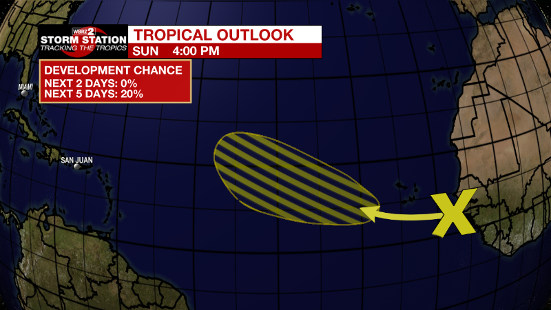
Eastern Tropical Atlantic:
Limited shower and thunderstorm activity is associated with a
tropical wave located just off the west African coast. An area of
low pressure could form later this week and subsequent gradual
development is possible as this system moves generally
west-northwestward over the eastern and central tropical Atlantic.
* Formation chance through 48 hours...low...near 0 percent.
* Formation chance through 5 days...low...20 percent.
More News
