

Latest Weather Blog
Sunday PM Forecast: Heat Advisory extended, Air Quality Alert day for Monday
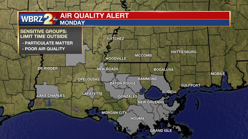
Heat Advisory extended and air quality alert day.
THE FORECAST
Tonight & Tomorrow: Temperatures will start to cool down as we head into the overnight hours into the mid-70s. Waking up Monday morning to some clouds and humidity. Temperatures will be heating up into the mid-90s throughout the day. Heat index will be in the triple digits for a greater part of the day. A Heat Advisory has been issued for Monday until 7 p.m. Heat index values are expected to climb between 108-110°. With the heat advisory today make sure you are limiting time outdoors, staying hydrated, and checking on your pets. A shower will be possible in the afternoon hours but most will stay completely dry. Air quality alert day for Monday, June 13th. Air quality may be unhealthy for sensitive groups.
A Heat Advisory has been issued for the following parishes:
Pointe Coupee, West Feliciana, East Feliciana, St. Helena, Iberville, West Baton Rouge, East Baton Rouge, Assumption, St. James, Ascension, Tangipahoa, and Wilkinson, Amite, and Pike counties.
Heat Advisory is set to expire on Monday, June 13th at 7 p.m.
Trending News
Sun and Heat Safety: Some friendly reminders for your summer of fun events—sunburn can occur in less than 15 minutes with the extreme U.V. Index typical of this time of year. In addition to that, heat exhaustion and heat stroke can set in just as quickly. Seek medical attention if you or somebody you know is affected. While we all enjoy a list of cool beverages, be sure water is at least a part of that list! Finally, look before you lock. DO NOT leave people or pets in an unattended car.
Up Next: Into the work week the trend will continue. Some moisture will be sticking around in the morning hours. Waking up temperatures will be in the mid-70s and feeling muggy. Throughout the day the skies will be mostly sunny. Temperatures will peak in the mid-90s but feels like temperatures will be in the low triple digits. A quick shower may pop in during the afternoon hours, but most will stay completely dry and hot. The heat will be sticking around all week so be sure you have a way of beating the heat during peak daytime heating hours. The pattern continues throughout the week and temperatures continue to rise until our next rain chance comes in on Wednesday.
Click here to see the 7-day forecast.
Hour-by-hour weather tracking is available for your location on the WBRZ WX App on your Apple or Android device. Follow WBRZ Weather on Facebook and Twitter for even more weather updates and unique weather insight from the whole team!
In the Tropics:
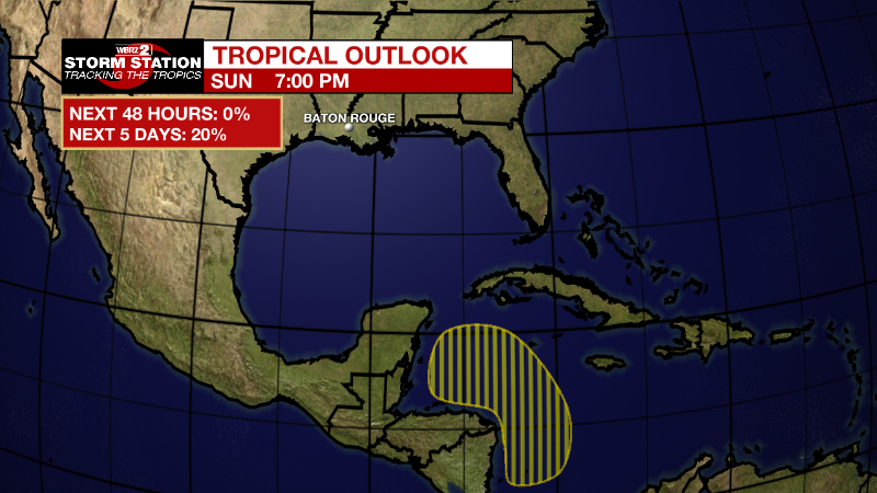
For the North Atlantic...Caribbean Sea and the Gulf of Mexico:
Southwestern Caribbean Sea:
An area of low pressure is expected to develop by the middle part
of this week over the southwestern Caribbean Sea. Some slow
development of this system is possible while it drifts generally
northwestward off the coasts of Nicaragua and Honduras.
* Formation chance through 48 hours...near 0 percent.
* Formation chance through 5 days...20 percent.
More News
