

Latest Weather Blog
Shower and storm activity rising, busy in the tropics
Happy Hump Day! Shower activity is on the rise.
THE FORECAST:
Today and Tonight: A weak boundary will be moving through today acting as the spark for some afternoon showers. Everyone from the Mississippi counties down to the coast has about an even chance of catching a shower or two. These storms could pack a punch with gusty winds, frequent lightning, and a heavy downpour. If you don’t see any rain, you may still see building clouds from a neighboring storm. Unless rain is falling on your head, the temperatures will still be near a toasty 94 degrees. All the showers will die out as the sun goes down and the overnight lows will be near 72.
Up Next: A slight wind shift and low pressure will promote scattered shower activity on Thursday. Everyone should look out for some shower activity. It will not be a total washout, but rain will start earlier in the day and last through much of the afternoon and evening. Temperatures on Thursday will be near 91 with overnight lows near 72. Rain coverage between 30-40% is expected every afternoon for the rest of the 7-day forecast. Temperatures for the rest of the week will hover around 92 during the day and 72 overnight.
The Tropics: Eyes are still on the two tropical waves out in the Atlantic. The conditions look good for tropical development, but there are still many possibilities for the outcome of these storms. It is possible for these systems to move into the Gulf of Mexico, but it is too early to know for certain. The WBRZ Weather Team is monitoring these systems around the clock. We will be the first to let you know of any new information.
Trending News
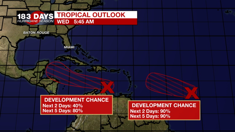
Tropical Outlook Information:
A tropical wave located over the eastern Caribbean Sea is producing disorganized showers and thunderstorms, along with gusty winds in these thunderstorms. Significant development of this system is unlikely during the next day or so while it moves quickly westward at about 20 mph across the eastern and central Caribbean Sea. After that time, however, the wave is forecast to move more slowly west-northwestward, and a tropical depression is likely to form late this week or this weekend when the system reaches the northwestern Caribbean Sea.
* Formation chance through 48 hours...medium...40 percent.
* Formation chance through 5 days...high...80 percent.
An elongated area of low pressure, located a little over 1000 miles east of the Windward Islands continues to produce a concentrated area of showers and thunderstorms mainly on the west side of the disturbance. Environmental conditions are conducive for further development, and a tropical depression is expected to form during the next day or two while the system moves generally west-northwestward at 15 to 20 mph across the central and western portions of the tropical Atlantic.
* Formation chance through 48 hours...high...90 percent.
* Formation chance through 5 days...high...90 percent.
The WBRZ Weather Team is here for you, on every platform. Your weather updates can be found on News 2, wbrz.com, and the WBRZ WX App on your Apple or Android device. Follow WBRZ Weather on Facebook and Twitter for even more weather updates while you are on the go.
More News
