

Latest Weather Blog
SEVERE THUNDERSTORM WATCH
Update: 6:55pm
A severe thunderstorm watch issued for areas north of I-12 in WBRZ Viewing Area.
The National Weather Service has issued a severe thunderstorm watch for Pointe Coupee, W. Feliciana, E. Feliciana, St. Helena, E. Baton Rouge, W. Baton Rouge, and Livingston parishes, and Amite, Pike, and Wilkinson counties until 12:00AM.
A SEVERE THUNDERSTORM WATCH means conditions may develop that lead to severe thunderstorms in and near the watch area, it does not mean that they will occur. Severe thunderstorms can have winds excess 58mph or hail that is one inch in diameter or larger. Severe thunderstorms can produce flash flooding and tornadoes. For more on severe thunderstorm safety, CLICK HERE.
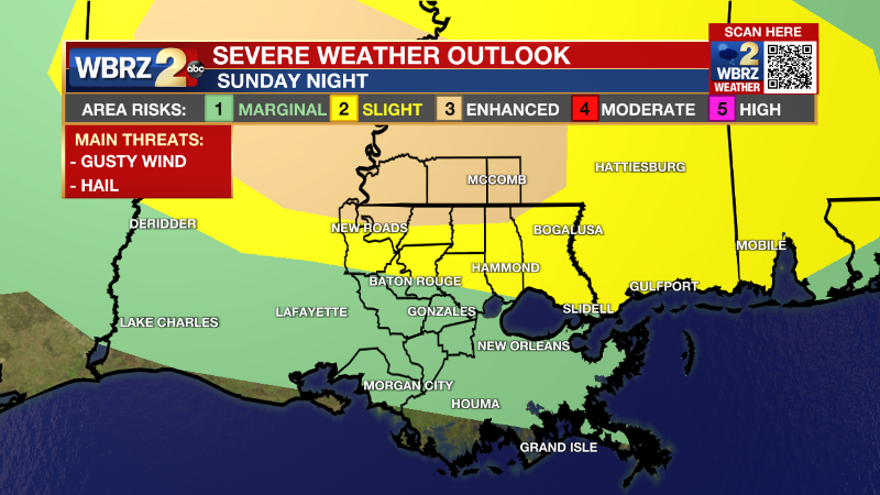
Parts of our viewing area have been increased to an enhanced level 3/5 risk for severe weather this evening. This includes Wilkinson, Amite, and Pike counties, and the northern most parts of E. Feliciana, W. Feliciana, St.Helena, Tangipahoa, and Pointe Coupee parishes. The main threats still being for gusty winds and hail, and a low threat for a tornado.
Tonight: Thunderstorms will be capable of damaging wind gusts, isolated hail events, and though the threat is low, it is possible that an isolated tornado is spawned as well. Heavy rain could leave to isolated street and poor drainage flooding issues. The showers and thunderstorms will move along a cold frontal boundary that pushes through from 6pm-12am. Behind the line we will see winds shift out of the north guiding temperatures to the mid 60s.
Trending News
Monday and Beyond: Rainfall totals through the frontal passage should generally be around one inch for areas north of I-12, but locally higher amounts are possible. Once the cold front moves through clearing conditions are expected. For the rest of the week our temperatures are briefly dropping back down into the high 70s- low 80s. Little rain expected as we head further into the week. Sunny skies are ahead.
Click here to see the 7-day forecast.
Reminder: With the threat for impactful weather— severe storms and heavy rain—please have access to alerts. You can download or activate the WBRZ WX App on your Apple or Android device or turn on a NOAA Weather Radio for bulletins such as watches and urgent warnings. Of course, WBRZ, WBRZ+ and the Cable Weather Channel will have updates as active weather dictates.
More News
