

Latest Weather Blog
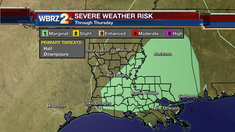
Scattered storms continue, downpours and hail possible
After one more day with rain in the forecast, unsettled weather will finally slacken off.
THE FORECAST:
Today and Tonight: Thursday will bring another bout of scattered showers and thunderstorms—precipitation is not expected to be as heavy and widespread as Wednesday though. Most of the rain will be south of I-10 early, with scattered showers and storms north of the interstates later. An isolated severe storm is possible with hail being the main threat from stronger thunderstorms. Where downpours occur, another inch or so of rain will be possible as well. Temperature should fair a little better with less rain. Expect a high in the mid 70s. Overnight, much of the shower action should be over. With lingering clouds, lows will stop in the low 60s.
Up Next: Friday may begin with some cloud cover and even a lingering shower though skies will reveal a little more sun in the afternoon. Highs will be in the upper 70s. Saturday and Sunday will bring partly sunny skies with lows in the low 60s and highs pushing 80 degrees. A spotty shower can’t be ruled out, especially in coastal areas, however much of the time will be dry.
Trending News
THE SCIENCE:
Forecast Discussion: Another wave of vorticity will sweep across the region on Thursday. However, with the stalled front displaced farther to the south in the Gulf of Mexico—thinking is that the axis of heavier rain will also migrate southward. Still, scattered action will remain possible through Thursday Night with an additional inch of rain possible. The severe weather threat remains low, however as was the case on Wednesday, some hail is possible with deeper storms as the freezing layer is quite a bit lower than usual for our area. The better instability, and thus greater chance for a severe storm, will be mainly north of the interstates. Moving into Friday, the axis of that shortwave trough should be east effectively ending uplift and the chance for precipitation in the local area. Upper ridging atop low level moisture may result in considerable cloudiness early Friday, but diurnal heating will help to mix this layer out to reveal some afternoon sun. It remains difficult to go with an all dry forecast Friday through Sunday; however an upper ridge shown on the forecast models lends more credence to this notion. Additionally, a broad surface high pressure system will be nudging southwestward from the Northeast U.S. promoting fair weather for a large chunk of the Eastern U.S. Our locale appears to be on the periphery of the surface high’s reach. An upper trough in the Southwest U.S. will loop waves of vorticity around just to our west. Should a bit of energy sneak east, enough surface moisture would be available to trigger spotty showers—especially closer to the coast. For these reasons, we may have to carry 10-20% rain chances Friday to Sunday.
For updates, stay connected with Meteorologist Josh Eachus:
More News
