

Latest Weather Blog
Scattered showers for Wednesday and dry skies on Thursday
One more rainy day before a much needed break from the rain on Thursday and Friday.
THE FORECAST:
Today and Tonight: Wednesday will start dry and shower activity will grow in the late morning and early afternoon hours. Though many areas have had recovery time from all the rain, a heavy downpour could cause some standing water. The sun will poke through during dry times and temperatures to climb to near 88 degrees. Overnight lows will be near 75. This will be the last rainy day before dry conditions take over.
Up Next: By Thursday much of the tropical moisture in our area will move out leaving us with just a few showers and storms possible in the afternoon. Thursday and Friday will offer enough dry time to finish any lawn work and spend time outside. Expect only 10% rain coverage. The temperatures will be in the low 90s and overnight lows in the mid-70s. Larger rain coverage is expected for the weekend. Between 30-40% with high temperatures hovering right around 90 degrees.
Trending News
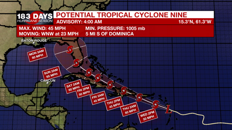
The Tropics: Potential Tropical Cyclone Nine
The disturbance is centered near latitude 15.3 North, longitude 61.3 West. The system is moving toward the west-northwest near 23 mph (37 km/h), and this general motion with some slight reduction in forward speed is expected over the next few days. On the forecast track, the center will move through the southern Leeward Islands during the next few hours, near or over the Virgin Islands and Puerto Rico tonight, near or over Hispaniola on Thursday, and near or over the southeastern Bahamas on Friday.
Maximum sustained winds remain near 45 mph (75 km/h) with higher gusts. Some increase in strength is forecast today, with weakening likely on Thursday due to land interaction, and some restrengthening possible late week.
Environmental conditions are expected to be conducive for additional development, and a tropical storm is forecast to form later today. Formation chance through 48 hours...high...90 percent. Formation chance through 5 days...high...90 percent.
Tropical-storm-force winds extend outward up to 275 miles (445 km) from the center. Antigua recently reported a wind gust of 47 mph (76 km/h).
THE EXPLANATION:
Deep moisture is still present. Precipitable water values exceed 2 inches and any small disturbance will activate heavy rain. By tomorrow PW values will drop between 1.5-1.7 inches. That is still plenty of moisture for some afternoon rain, but we will see much less of it. An upper-level trough is dropping over the Great Lakes region. As this moves off the east, high pressure will build over the Gulf pushing out all the deep moisture. Less moisture means the air will be able to heat and cool more efficiently and highs will have no trouble reaching the 80s. A line of showers and storm associated with a front will move through the area on Friday evening. We are keeping a close eye on development because there will be large amounts of CAPE and plenty of available dry air for entrainment. A shortwave will spark up more frequent shower activity over the weekend.
--Marisa
The WBRZ Weather Team is here for you, on every platform. Your weather updates can be found on News 2, wbrz.com, and the WBRZ WX App on your Apple or Android device. Follow WBRZ Weather on Facebook and Twitter for even more weather updates while you are on the go.
More News
