

Latest Weather Blog
Saturday PM Forecast: Enjoy the dry time tonight, more showers expected tomorrow
Rain should not be interrupting any dinner plans.
THE FORECAST
Tonight & Tomorrow: Showers and storms continuing to clear out of the area this afternoon. Cloud cover and humidity will be sticking around into the evening hours. Temperatures overnight will fall into the mid-to-low 70s. Waking up Sunday morning the rainy, humid pattern is set to repeat. A shower is possible during the early morning hours but most will be fueled later in the day by daytime heating. Temperatures will get into the low-90s before showers are expected to come in and cool temperatures down. Heat index values could be nearing triple digits depending on when and where showers and cloud cover sets up. By the late afternoon hours showers will be well out of the area. Cloud cover will linger overnight and we are expected more of the same pattern for Monday.
Up Next: The start of your workweek is looking a lot like the same rise and repeat pattern we’ve seen this week. Temperatures starting your day will be in the mid-to-low 70s with mostly sunny skies. As we go throughout the day, you chance of seeing a shower increases as temperatures heat into the mid-80s. Showers and storms have the potential to produce heavy downpours, frequent lightning, and gusty winds. Shower activity will begin to settle down as the sunsets. Overnight temperatures will be in the mid-70s. Tuesday is looking like a near repeat with more widespread showers expected. Click here to see the 7-day forecast.
Reminder: Be sure you are staying connected to stay ahead of these showers and storms. Hour-by-hour weather tracking is available for your location on the WBRZ WX App on your Apple or Android device. Follow WBRZ Weather on Facebook and Twitter for even more weather updates and unique weather insight from the whole team!
In the Tropics:
Trending News
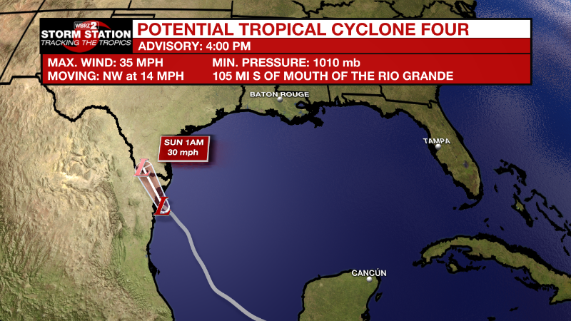
As of 4pm Friday, the National Hurricane Center started issuing advisories on Potential Tropical Cyclone Four. It currently has 35mph winds with a minimum central pressure of 1010mb and is moving northwest at 14mph. On the forecast track, the disturbance is expected to approach the coast of northeastern Mexico on Saturday and make landfall there Saturday night. Slow strengthening is expected through landfall. No impacts to the local viewing area.
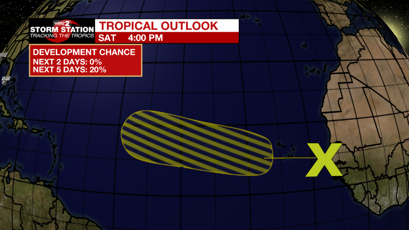
Eastern Tropical Atlantic:
A tropical wave located near the west coast of Africa is producing
disorganized showers and thunderstorms. Environmental conditions
are expected to be marginally conducive for gradual development of
this system while it moves westward to west-northwestward at 15
to 20 mph across the eastern and central tropical Atlantic during
the early to middle part of next week.
* Formation chance through 48 hours...low...near 0 percent.
* Formation chance through 5 days...low...20 percent.
More News
