

Latest Weather Blog
Saturated Baton Rouge area looks to a drying trend
To date, 2021 has been the wettest year on record at Metro Airport with data going back to 1930. Though we could add to those totals early in the week, the threat for additional flooding has diminished.
Next 24 Hours: Any evening showers or thunderstorms will fizzle during the overnight hours. Beneath partly cloudy skies, low temperatures will bottom in the low 70s. A muggy morning with some sunshine will see high temperatures reach the upper 80s by early afternoon. With the peak daytime warming, scattered showers and thunderstorms are expected. Storms should not be very long-lived, so no significant issues are expected.
It has been a while since we talked about rain coverage—the percentages on the forecast board often seen during the warm season. Here is a quick reminder about what those mean for the WBRZ Weather 13 Parish, 3 County forecast area.
10-30% - Isolated: a few locations receive measurable rain
30-60% - Scattered: part to half of the area receives measurable rain
60-100% - Widespread: almost all of the area receives measurable rain
Keep in mind, those chances tell nothing about timing. For instance, 100% DOES NOT mean it will rain all day. We will be sure to provide information in our forecasts as to when you can expect rain when chances are on the board. MORE: https://www.wbrz.com/news/a-chance-to-remember
Trending News
Up Next: The pattern of scattered, afternoon showers and thunderstorms will continue on Wednesday. By the end of the week, a warmer and more stable atmosphere should provide a change in fortune for saturated, rain weary areas. Thursday through Saturday should be mainly dry with 20 percent coverage or less in afternoon showers. The partly sunny skies will easily allow temperatures to reach 90 degrees or higher. Nights will be still and sticky, in the low to mid 70s. CLICK HERE for your full 7-Day Forecast.
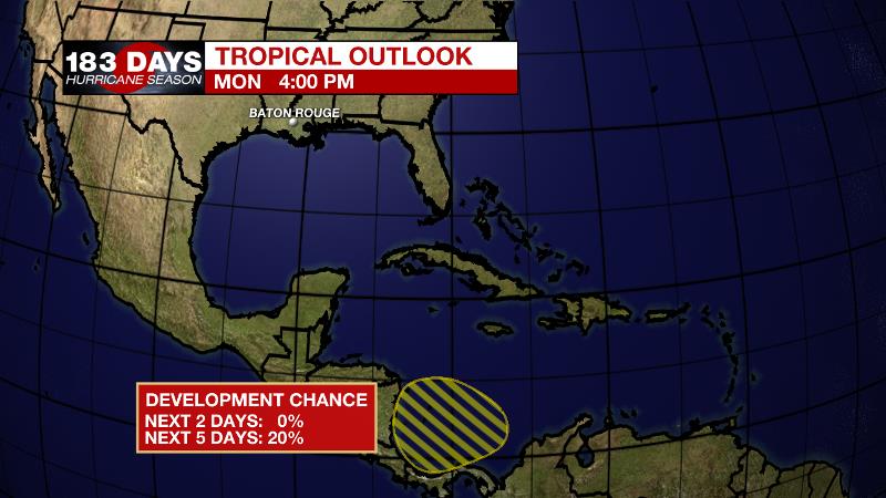
The Tropics: An area of low pressure is expected to develop over the southwestern Caribbean Sea by Thursday or Friday. There is a 20 percent chance of some gradual development as the system moves slowly northwestward toward Central America. Be sure to visit the WBRZ Hurricane Center as we navigate all 183 Days of Hurricane Season.
The Explanation: An upper level trough will continue to weaken north of the area on Tuesday. Still, this mechanism will provide enough instability and with the axis of the trough, technically west of the area, some aid in lift as well. Atmospheric moisture will remain above average on Tuesday and so scattered showers and thunderstorms are possible, especially north of I-12, closer to the upper level trough. Any outflow boundaries from previous storms may serve as a focus for initiation of new development. After a quiet night, one more repeat is in store for Wednesday. Beginning on Thursday, a strong upper level ridge over Mexico and the Central U.S. will start to broaden across the country. This will gradually bring a lowering of daily rain coverage through the end of the week and that trend will continue over the weekend as the ridge builds overhead. Of course, a lack of rain will push high temperatures back into the seasonably hot low 90s. By the end of next weekend, or early next week, an upper level trough moving out of Canada will swoop south and dampen the ridge leading to a return of more typical, afternoon showers and thunderstorms.
--Josh
The WBRZ Weather Team is here for you, on every platform. Your weather updates can be found on News 2, wbrz.com, and the WBRZ WX App on your Apple or Android device. Follow WBRZ Weather on Facebook and Twitter for even more weather updates while you are on the go.
More News
