Rain on the way, it could be heavy at times
After two quiet days, rain will return to the forecast for the rest of the week. It could be heavy at times leading to some poor drainage and even river flooding.
Next 24 Hours: One more quiet night is ahead. Clouds will increase into Tuesday morning therefore stopping low temperatures in the low 60s.

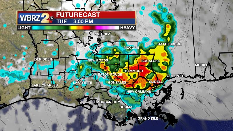
Thermometers will have a little time to climb early Tuesday before rain begins. Highs should make it into the mid 70s. Showers will break out by mid-to-late morning. Tapping into some daytime warmth, thunderstorms are expected to develop as well. At first, some for the storms could cause gusty wind or hail. However, later in the day, the main threat from any storms will be frequent lightning and downpours. Some locations could pick up a quick few inches meaning that street and poor drainage flooding is possible. Activity should settle down into the evening followed by nighttime lows in the mid 60s.
Up Next: Wednesday will be another with widespread rain and thunderstorms. Again, a few locations could stack inches into gauges causing localized flooding. The dreary weather will keep thermometers in the 70s.
Trending News

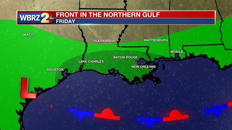
A front will pass through the area on Thursday with more of the scattered variety of showers and thunderstorms. Stalling offshore, the front will still cause scattered showers on Friday and Saturday with more activity closer to the coast and more breaks inland. Remaining beneath mainly cloudy skies and holding north winds behind the front, cooler than average high temperatures are expected Thursday through the weekend. 7-Day rainfall totals will be around 3 – 6 inches, with most of that falling on Tuesday and Wednesday. These amounts could cause local rivers to top flood stage, so stay tuned for updates. CLICK HERE for your full 7-Day Forecast.
The Explanation: An ill-defined warm front will setup over the region on Tuesday as a slow moving surface low moves into eastern Texas. A round of showers and thunderstorms will develop near the surface low and then move east along the front into Louisiana. An upper level disturbance moving over this storm system will enhance rain and thunderstorms. This scenario is expected to repeat on Wednesday. Onshore flow in the low levels will allow unseasonably high moisture into the atmosphere while temperatures will cool significantly with height leading to ample instability. Thunderstorms over the two day stretch are expected to be efficient rainmakers and any could drop a quick few inches. While the ingredients for severe weather are not even close to the levels seen last week, some gusty wind and hail is possible with stronger thunderstorms. The Storm Prediction Center has placed the area in a 1/5 “marginal risk” on Tuesday for this possibility. However, heavy rain will be the primary concern. Street and poor drainage flooding is an obvious possibility but the smaller, local rivers are still running high due to runoff from the Saturday morning storm system. Additional amounts could drive some over flood stage. The associated cold front will finally drive through on Thursday with scattered showers and thunderstorms. The front will linger in the northern Gulf of Mexico to leave daily rain chances on the board. A surface low is expected to form and track along the front bringing another round of rain inland Friday into Saturday. By the end of the weekend, 7-day rain totals will range from 3 to 6 inches with the highest amounts expected around the lakes. As always, a locally higher amount is possible. Most of it should fall early in the week.
--Josh
The WBRZ Weather Team is here for you, on every platform. Your weather updates can be found on News 2, wbrz.com, and the WBRZ WX App on your Apple or Android device. Follow WBRZ Weather on Facebook and Twitter for even more weather updates while you are on the go.


