

Latest Weather Blog
One more rainy day, hot and steamy weekend ahead
Rain is still in the forecast for today. Look out for rain on the evening commute, but rain totals today will be less than the past two days.
THE FORECAST:
Today and Tonight: Wednesday will be the start of a heat up in south Louisiana. Temperatures will be near 91 this afternoon with a few showers and storms possible, mostly north of Baton Rouge. Those that do not see any rain may heat well into the middle 90s. The Flash Flood Watch has expired, but storms today could be capable of a brief heavy downpour frequent lightning and gusty winds (typical of summertime storms). Overnight any lingering showers will dry out and lows will be near 75 degrees.
Up Next: Thursday will be drier and warmer with temperatures climbing well into the 90s and afternoon pop-up showers very few in number. Overnight lows will warm up a little too and be near 76. Just a few showers and storms are expected each afternoon. Temperatures will continue to climb with Friday’s highs near 93 and even warmer for the weekend. Lows will be in the mid 70s all week.
Trending News
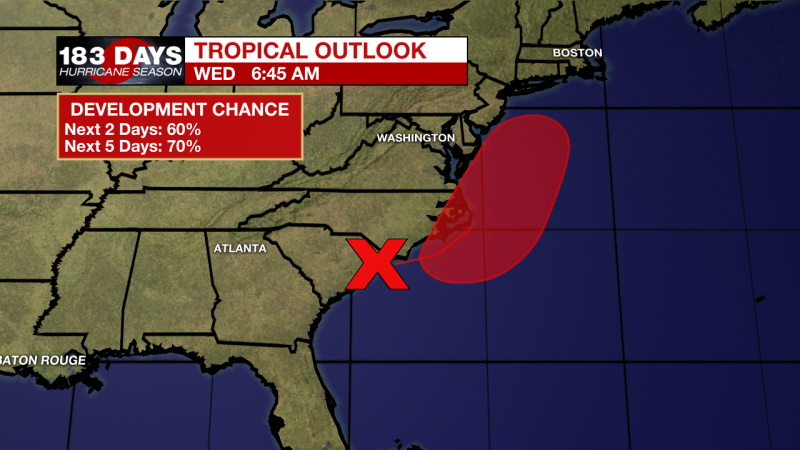
The Tropics:
An elongated area of low pressure is located along the coast of northeastern South Carolina. This system is producing a large area of disorganized showers and thunderstorms over the adjacent Atlantic waters. The low is expected to move northeastward near or just offshore of the North Carolina Outer Banks on Thursday, and then turn north-northeastward and move along the mid-Atlantic coast Friday. Environmental conditions are expected to be conducive for development, and a tropical or subtropical cyclone is likely to form within the next couple of days. Regardless of development, the low is expected to produce locally heavy rainfall that could cause some flash flooding across portions of eastern North Carolina, the coastal mid-Atlantic, and southern New England during the next few days. Gusty winds are also possible in the North Carolina Outer Banks through Thursday. Formation chance through 48 hours...medium...60 percent. Formation chance through 5 days...high...70 percent.
THE EXPLANATION:
A high and dry pattern is on the way. A ridge that is currently over the 4 Corners will start to dig and expand eastward toward us on Wednesday. This will increase subsidence and bring dry air further east. Rain chances and coverage will slowly decline as this dry air moves in. 500 mb heights are also expected to increase. Temperatures will climb well into the 90s by the end of the week and stay that way through the weekend.
--Marisa
The WBRZ Weather Team is here for you, on every platform. Your weather updates can be found on News 2, wbrz.com, and the WBRZ WX App on your Apple or Android device. Follow WBRZ Weather on Facebook and Twitter for even more weather updates while you are on the go.
More News
