

Latest Weather Blog
NEW: changes made to weekend forecast
The forecast remains on track for a warmer and quiet end to the week. However, there have been significant changes to the weekend forecast that could affect plans.
The Next 24 Hours: Another clear and cold night is ahead. Low temperatures will stop in the upper 30s and low 40s. Frost is less likely, even in the traditionally cooler locations. Wednesday will be another afternoon filled with sunshine as high temperatures shoot for the 70s. Winds will be light and southwesterly.
After That: Thursday will begin in the 40s and there is expected to be enough sunshine for high temperatures to top out in the mid 70s. By afternoon, some cirrus clouds may spill across skies. The next frontal system is pegged for Friday night and Saturday morning. A lack of deep moisture in the atmosphere should keep showers from developing until just ahead of and along the front—most likely on Saturday morning. There could be an embedded thunderstorm or two. Previously, it appeared this system would be in and out, and while the cold front is still expected to pass on Saturday, lingering moisture may lead to a dreary Sunday as well. CLICK HERE to view your complete 7-Day Forecast.
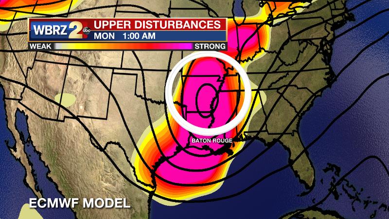
The Explanation: Sunshine will stick around through at least Wednesday. By that time, a weak upper level ridge will pass across the central Gulf Coast states leading to some compressional warming. Highs will go above average on Wednesday afternoon and subsequent highs and lows will then go up a few degrees each period through the week. As the next storm system organizes in the Southwest, west to southwest winds through the atmosphere will begin to increase moisture. Some cirrus clouds should first be noticed on Thursday afternoon with the low levels presenting thicker cloud cover by Friday. Still, the column should be too dry to supper any showers. A cold front will push through the region on Saturday morning and provide enough lift for scattered showers and possibly a thunderstorm or two. The forecast gets a little bit tricky after this. Models are having a difficult time resolving how the weekend plays out due to current complexities in the upper level pattern. Other than the American model, most guidance points to the upper level trough lagging back to the northwest, well behind the front. The consequence of this outcome is that moisture will continue to stream into the atmosphere behind the front leaving dreary weather including clouds and some showers through Sunday.
Trending News
If the upper level is as potent as the European model indicates, rain could be heavy at times on Sunday. Cool and quiet weather will be restored, if only for a short time Monday into Tuesday. The next system is already advertised for next Tuesday night.
--Josh
The WBRZ Weather Team is here for you, on every platform. Your weather updates can be found on News 2, wbrz.com, and the WBRZ WX App on your Apple or Android device. Follow WBRZ Weather on Facebook and Twitter for even more weather updates while you are on the go.
More News
