

Latest Weather Blog
Monday PM Forecast: clouds thicken before big warm up
After a period of clouds, warm temperatures will be the story of the week. We are watching a storm system, which will near the region this weekend.
Next 24 Hours: Some high clouds will cycle through the area tonight as low temperatures drop into the mid 50s. Even though some sunshine will be available, a cirrus deck will be the main feature in skies on Tuesday. With that, high temperatures will level off in the upper 70s.
Up Next: Once clouds exit, mainly clear skies are expected for the rest of the workweek. Wednesday, Thursday and Friday will be mostly sunny with highs in the low to mid 80s—about 5-8 degrees above average for the time of year. Nights will be noticeably more muggy with lows in the low to mid 60s. The weekend forecast is still coming together and requires attention. A weakening cold front will approach the area Saturday into Sunday. The exact speed and track of the system will determine if, and at what point, some showers and thunderstorms work into the area. As of now, the idea is that a broken line of showers will move in Saturday night into Sunday. CLICK HERE for your detailed 7-Day Forecast.
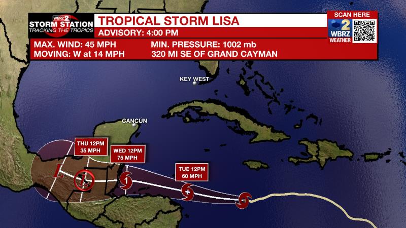
The Tropics: Tropical Storm Lisa is slowly moving westward across the Caribbean Sea at 14mph with maximum sustained winds of 45mph. Tropical Storm conditions are possible in Jamaica on Tuesday as Lisa continues moving to the west-northwest with gradual strengthening. The system could be a hurricane as it nears Central America on Wednesday.
Trending News
The Explanation: A weak, shortwave trough of upper level low pressure will move from Texas through the Mid-Mississippi River Valley on Tuesday. As this occurs, atmospheric moisture will increase, primarily in the upper half. This will lend to increasing mid to high level clouds thickening through the day. The lack of lower level moisture may preclude any precipitation with the best chance for a stray shower near the coast. BY Wednesday, the trough will be weakening further and east of the area as an upper level ridge of high pressure expands over the Gulf Coast. This sturdy ridge will continue the overall drier pattern that we';ve grown used to this autumn. Additionally, in response to the ridge, subsidence will cause above average temperatures with highs in the 80s and lows in the 60s through the weekend. The end of the forecast gets a bit more challenging and interesting. A sharp upper level trough of low pressure will cut out of the Mid-South into the Ohio Valley. Substantial moisture is expected to be in place across the area with plenty of warmth at the surface. The track of the upper level trough will determine if there is enough cooler air aloft and therefore instability, and a trigger for showers and thunderstorms. If the trough moves farther north, a largely dry weekend may be expected. Any farther south than is currently expected and a threat for severe weather could even materialize. Stay tuned.
--Josh
The Storm Station is here for you, on every platform. Your weather updates can be found on News 2, wbrz.com, and the WBRZ WX App on your Apple or Android device. Follow WBRZ Weather on Facebook and Twitter for even more weather updates while you are on the go.
More News
