Monday AM Forecast: Ida's assault ending, rain bands remain possible
With the weakening Ida pushing northeast of the area, more typical summer weather will be restored. Unfortunately, that will mean heat and humidity as well as afternoon showers and thunderstorms as cleanup and restoration begins.
Next 24 Hours: Ida will accelerate northeastward and away from the local area through Monday. Some bands of rain will still spiral on the southern side of the storm and cause intermittent heavy showers, especially during the first half of Monday. Breezes of 20-30mph remain possible in these showers. There will be enough breaks in rain and maybe even a few peeks of sun to allow high temperatures to reach the upper 80s. By nighttime, activity should really start to diminish but muggy low temperatures in the mid 70s will not be welcome across an area largely without air conditioning.
Up Next: Tuesday and Wednesday should feature sunny mornings allowing high temperatures into the low 90s. As you might expect, showers and thunderstorms will be scattered around the area into the afternoon hours. Those overnight lows will be persistently uncomfortable in the mid 70s. The end of the week will trend drier, and in some good news, maybe even with lower humidity. Thursday and Friday will be mostly sunny with highs near 90s and lows near 70. CLICK HERE for your full 7-Day Forecast.
The Tropics: As of 12 pm Monday, Ida was weakening and moving north through Mississippi. Maximum sustained winds were dropping below hurricane force and will drop through the day as the system quickly degenerates. Heavy rain and tornadoes will remain a threat through much of Mississippi, Alabama and states into the Mid-Atlantic.
A tropical wave is expected to emerge off the west coast of Africa later today. Environmental conditions appear conducive for the development of a low pressure area once the wave moves offshore, and there is an 80 percent chance that a tropical depression forms by the middle or latter part of the week while it moves west-northwestward at 10 to 15 mph.
A broad area of low pressure is expected to form in the southern Caribbean Sea over the next several days. Environmental conditions appear to be favorable for some slow development by the end of the week, as long as the system remains over water. The five day formation chance is set at 20 percent while this system is expected to move gradually west-northwestward or northwestward at 5 to 10 mph over the western Caribbean Sea close to the east coast of Central America.
Trending News
For the latest tropical forecasts, advisories and information, visit the WBRZ Hurricane Center as we navigate all 183 Days of Hurricane Season.

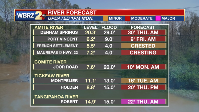
The Explanation: After the center of the storm exits the area Monday, there are indications that a feeder band will remain in place across the region. This could focus training thunderstorms across the same area tomorrow afternoon into tomorrow night. At this time, this band looks to develop over the river parishes and then drift to the southeast toward the coast. Given the heavy rainfall caused by Ida, flash flooding issues will continue to be a risk. This convergence band will likely persist through Tuesday night, and this will help keep temperatures a bit cooler than average through the short term. Highs will likely only warm into the mid to upper 80s through Tuesday. By Thursday, deep northerly flow will take hold of the region and usher in a much drier and more stable atmosphere. Daily rain coverage will go below 20 percent and some weak cool air advection will also occur, and this should help with recovery efforts. Temperatures are projected to dip into the 60s and lower 70s at night and highs are only expected to rise into the upper 80s. Humidity values will also be a bit lower than normal for early September.
--Josh
The WBRZ Weather Team is here for you, on every platform. Your weather updates can be found on News 2, wbrz.com, and the WBRZ WX App on your Apple or Android device. Follow WBRZ Weather on Facebook and Twitter for even more weather updates while you are on the go.


