

Latest Weather Blog
Memorial Day AM Forecast: Local area staying mostly sunny, Monitoring a tropical disturbance
There will be plenty of sunshine for your Memorial Day.
THE FORECAST
Today & Tonight: Your Memorial Day is looking mostly sunny and hot. Temperatures will be in the low 90s this afternoon with a stray shower or two in the afternoon. Most areas will stay dry. If you are going to be boating on the tidal lakes, keep an eye on the radar in the afternoon. Humid conditions last overnight with temperatures in the low 70s.
Use the WBRZ WX App to keep tabs on afternoon pop-up showers. Hour-by-hour weather tracking is available for your location on the WBRZ WX App on your Apple or Android device. Follow WBRZ Weather on Facebook and Twitter for even more weather updates and unique weather insight from the whole team!
Up Next: The regular summertime humidity will stick around through the week. Tuesday temperatures will be in the low 90s and a few stray showers will be possible. This same pattern is set to repeat every day this week. We are not tracking any total washouts. If you have outdoor plans in the afternoon, keep an eye on the radar, so you aren’t caught off guard. Showers will bubble up quickly and move out quickly too. Click here to see the 7-day forecast.
Sun and Heat Safety: Some friendly reminders as the intense heat makes a comeback—sunburn can occur in less than 15 minutes with the extreme U.V. Index typical of this time of year. In addition to that, heat exhaustion and heat stroke can set in just as quickly. Seek medical attention if you or somebody you know is affected. While we all enjoy a list of cool beverages, be sure water is at least a part of that list! Finally, look before you lock. DO NOT leave people or pets in an unattended car.
Trending News
In the Tropics:
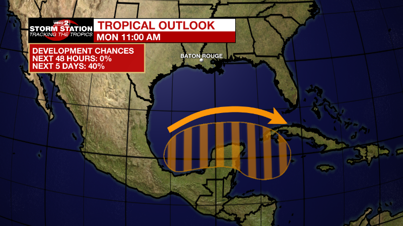
Near the Yucatan Peninsula: A large and complex area of low pressure is expected to develop
across Central America, the Yucatan Peninsula, and the southwest Gulf of Mexico in a few days, partially related to the remnants of Hurricane Agatha from the eastern Pacific. Some gradual development is possible within this system in the far southwest Gulf of Mexico around mid-week or in the northwest Caribbean by the latter part of this week as it drifts eastward or northeastward. Regardless of development, locally heavy rains will be possible across southern Mexico, the Yucatan Peninsula, Guatemala, and Belize through the week. This is NOT expected to impact south Louisiana.
Formation chance through 48 hours...low...near 0 percent.
Formation chance through 5 days...low...40 percent.
More News
