

Latest Weather Blog
Just plain chilly Thursday morning, storms return Friday night
We have not put in a bottom on temperatures yet—that will occur Thursday morning. Pleasant weather is expected until a storm threat ramps up late Friday.
Next 24 Hours: Clear skies and light winds will set up an ideal night for radiational cooling. That is warmth collected via the sun by day will easily escape into the atmosphere by night. Low temperatures will dip into the low to mid 40s. A nice rebound will occur on Thursday afternoon with sunny skies and easterly winds pushing high temperatures to about 70 degrees. It is possible some cirrus clouds begin to show up late.
??!!! No weather worries through Friday morning. Here is what myself and the @WBRZweather Team are watching for you next ?? pic.twitter.com/xTfAON64u4
— Josh Eachus (@DrJoshWX) April 21, 2021
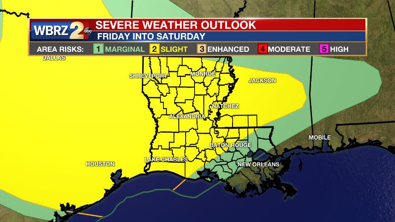
Up Next: A stronger storm system will cut across the southern third of the country Friday into Saturday. This one is expected to return showers and thunderstorms to the local area for about a 24-hour period. Fortunately, that will not allow for a long duration soak like the one we just experienced. However, the associated surface low will take a track close enough to the area to warrant the early 2/5 “slight risk” of severe weather posted by the Storm Prediction Center. Most likely, any stronger thunderstorms would occur late Friday night and early Saturday. Drying and clear is actually expected by Saturday afternoon, which should warm into the 80s. Sunday will be sunny and slightly cooler. CLICK HERE for your full 7-Day Forecast.
Trending News
The Explanation: By Thursday morning, persistent cold air advection and clear skies with lighter winds could allow some lows in the low 40s, especially north of I-12. Thursday will remain pleasant with the possibility of some cirrus clouds emerging by late in the day. By Friday, an area of high pressure positioned northeast of the local area will return southerly winds and moisture to the atmosphere. The advance of this air mass will occur along a warm front Friday afternoon with associated overrunning precipitation breaking out ahead of that. The associated cold front will run through by Saturday afternoon. Through this time, showers and thunderstorms are all that is expected. Moving into Friday night and Saturday morning, the Storm Prediction Center highlighting the entire local area with a 2/5 “slight risk” for severe weather.
The biggest questions, which will answer what type of severe weather could occur, will be whether the instability ahead of an approaching cold front can become rooted at the surface, and if enough of it will be present while low level winds are favorable. These details will become clearer over the next few days. The cold front will move into the Gulf of Mexico on Saturday night with drier air returning for the duration of the weekend. Another quiescent stretch with sunshine and warming temperatures will last through Tuesday.
--Josh
The WBRZ Weather Team is here for you, on every platform. Your weather updates can be found on News 2, wbrz.com, and the WBRZ WX App on your Apple or Android device. Follow WBRZ Weather on Facebook and Twitter for even more weather updates while you are on the go.
More News
