

Latest Weather Blog
High pressure is moving in to push the rain out
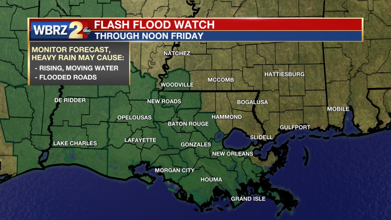
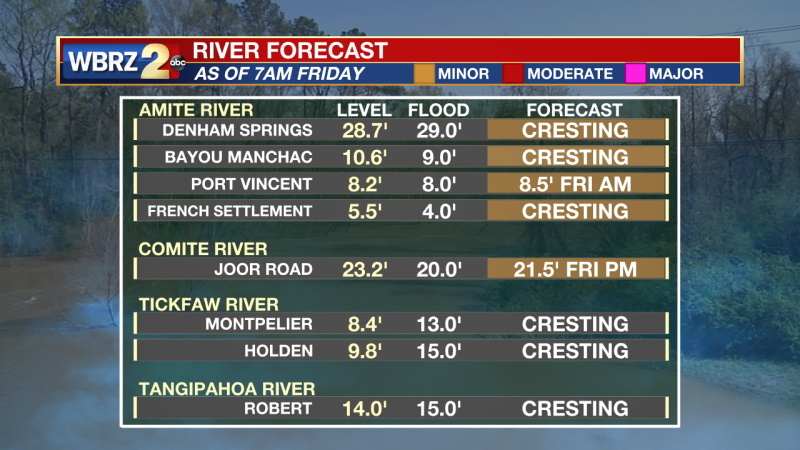
A FLASH FLOOD WATCH is posted for parts of the viewing area, through noon Friday. Additional rainfall of 1 inch with locally higher amounts will be possible. The most likely areas for heavy rainfall will be west of Baton Rouge and the Mississippi River. These heavier rainfall amounts could cause localized flash flooding issues. High rainfall rates could overwhelm drainage capacity. Ponding of water in low-lying and poorly drained areas will be possible, and flash flooding could occur where the heaviest rain occurs.
THE FORECAST
Today & Tonight: The moisture stream coming in from the Gulf is still producing rain in the area. Unlike every other day this week, high pressure will be moving in to push this stream off to the west. Areas west of the Mississippi River will see the bulk of the rainfall today. By the late afternoon, all the rain will be pushed west out of the WBRZ viewing area and the full dry out can begin. Temperatures this afternoon will be near 80 degrees and we will be in the 60s overnight tonight.
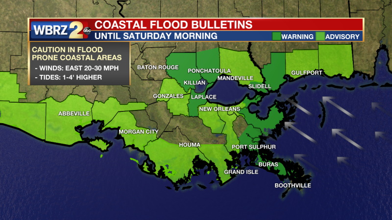
Up Next: The south and easterly winds causing coastal flood warnings will start to ease up by the end of the day Saturday. High pressure will settle in and keep rain out of the forecast for a while. Temperatures over the weekend will be in the mid-80s in the afternoon and 60s overnight. Next week will be mostly dry and warm with temperatures in the mid to upper 80s all week. Click here to see the 7-day forecast.
Trending News
In the Tropics: June 1st and the start of Hurricane Season are right around the corner. We are looking at the first disturbance of the season. It is located out in the Atlantic and will not be a concern for the Gulf of Mexico. NOW a second disturbance has caught the eye of the NHC in the Gulf of Mexico. We have been watching this disturbance all week and we have already felt the impacts in terms of rain all week. As the rain in our area pushes to the west, the disturbance in the Gulf will also push west and likely bring heavy rain to parts of Texas. This disturbance has not changed any details in our extended forecast.
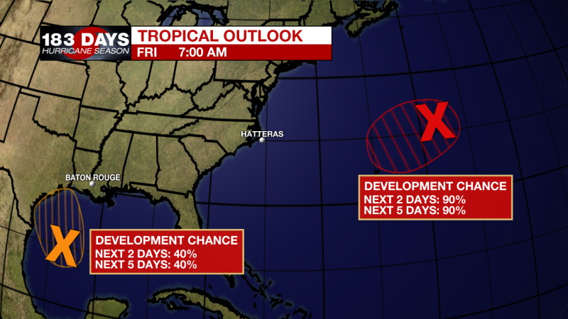
Showers and thunderstorms associated with a non-tropical low pressure area centered about 450 miles east-northeast of Bermuda have become better organized during the past several hours. The low has not yet acquired subtropical storm characteristics. However, if current trends continue advisories could be initiated on the system later today or tonight as it moves westward to west-southwestward to the northeast of Bermuda. Subsequently, the low is forecast to move northeastward into a more hostile environment by Saturday night or Sunday. Additional information on this low pressure area can be found in High Seas forecasts issued by the NOAA Ocean Prediction Center and forecast products, including a tropical storm watch, issued by the Bermuda Weather Service.
* Formation chance through 48 hours...high...90 percent.
* Formation chance through 5 days...high...90 percent.
Recent satellite imagery suggests that a low-level circulation is forming associated with the mid- to upper-level disturbance over the western Gulf of Mexico. However, shower and thunderstorm activity remains disorganized. Environmental conditions are expected to be marginally conducive for development, and a short-lived tropical depression or storm could form before the disturbance moves inland over the northwestern Gulf coast tonight. Regardless of development, the system could produce heavy rainfall over portions of southeastern Texas and southwestern Louisiana during the next few days. Additional information on the rainfall and flooding potential can be found in products issued by your local National Weather Service Forecast Office.
* Formation chance through 48 hours...medium...40 percent.
* Formation chance through 5 days...medium...40 percent.
Get right now weather conditions for your location on the WBRZ WX App on your Apple or Android device. Follow WBRZ Weather on Facebook and Twitter for even more weather updates and unique weather insight from the whole team!
More News
