

Latest Weather Blog
Grab your umbrella just in case
The scattered showers set to become more widespread as we approach the holiday weekend.
THE FORECAST
Today & Tonight: Today will be a bit drier than yesterday with rain coverage near 40% of the viewing area. Similar to yesterday, showers will bubble up just before noon and will move southeast to northwest. With some dry time this afternoon, temperatures will be warming into the upper 80s and the heat index will be in the upper 90s. Overnight temperatures will be back down in the 70s.
Up Next: On Wednesday, Thursday and Friday rain coverage will be between 40-50% of the area each day. When it’s not raining, temperatures will be toasty near 90 degrees, but the heat index will likely stay out of the triple digits. Click here to see the 7-day forecast. Although rain is in the forecast each afternoon, not everyone will see rain, and you should be able to find some dry time for yard work. Track out live radar for your location on the WBRZ WX App, and you can even set alerts for heavy rain! Download here.
Looking ahead to the weekend, a large cold front is going to drape over move of the US. It will slowly move from north to south concentrating all the available moisture over the Gulf Coast. The front will likely dissipate before reaching the area, so instead of cooling things off, it will be a rainmaker for the area on Saturday and Sunday. The afternoon hours look to be the most active with widespread showers that will die down later in the evening. Stay with us all week for new forecast details for the holiday weekend.
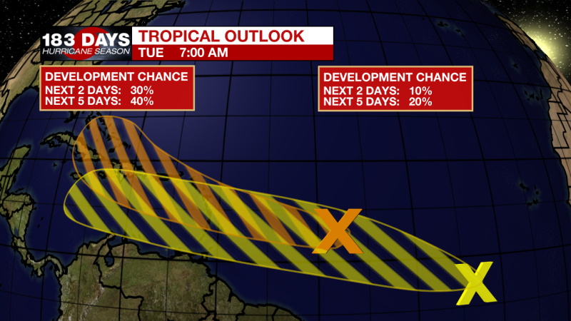
In the Tropics:
Danny has dissipated over Georgia this morning. Danny was briefly a tropical storm on Monday afternoon and dropped up to 8 inches of rain over parts of South Carolina. As that storm continues to fall apart, there are two disturbances we are monitoring in the Atlantic. The first has a 30-40% chance of developing in the next 5 days. Some development is possible by the end of the week, but this is just an area to watch as we head into next week. Now, the yellow ‘X’ is the newest wave to come off the coast of Africa. Development chances are still low, and we can add this to the areas to watch. Right now, neither disturbance is forecast to impact the local area. Stay with us for updates. Click here to visit the WBRZ Hurricane Center.
Trending News
Need weather conditions HOUR BY HOUR? Get hour by hour weather and right now weather conditions for your location on the WBRZ WX App on your Apple or Android device. Follow WBRZ Weather on Facebook and Twitter for even more weather updates and unique weather insight from the whole team!
More News
