

Latest Weather Blog
Game on: a weekend without rain
Calm weather and cooler air will highlight the weekend.
THE FORECAST:
Today and Tonight: The week will end with a mixture of sun and high clouds. Temperatures will make it into the mid 60s for most, but could potentially stay a little lower if thicker clouds filter out sun. Either way, have some warmer layers for the evening football games as kickoff temperatures in the 60s will quickly fall into the 50s by game’s end. Overnight will be mostly clear with a low in the mid 40s.
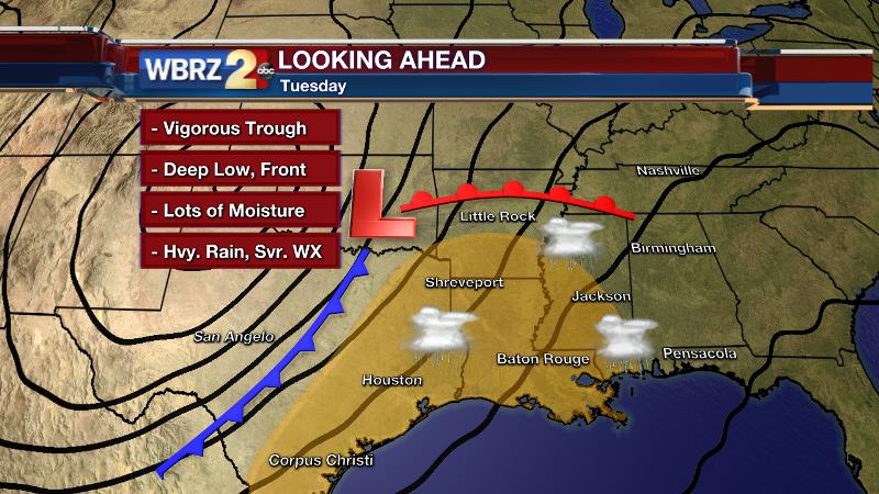
Looking Ahead: Saturday and Sunday are in fine shape for outdoor plans—maybe those that have been nixed out by several rainy weekends! Saturday will be mostly sunny early with some high clouds arriving beyond the morning. Highs will level off in the mid 60s. Tailgaters at LSU and Southern should carry a warmer layer or two as any shade or breezes will bring a chill. Plus, those heading into the games will notice temperatures quickly falling through the 50s after dark. Sunday will begin on a chilly note—in the mid 40s—with an afternoon rebound to the mid 60s under partly sunny skies. Enjoy the weekend and then be weather aware by early next week as a stormy pattern is setting up for Tuesday.
Trending News
THE SCIENCE:
Forecast Discussion: A strong surface high pressure system will set up north of the area on Friday and Saturday. Aloft, a thin layer of moisture traversing the mid-levels could provide a few patches of high clouds for the region. This could have some minor implications on temperatures via filtered sun. Despite generally quiet weather, this does make the forecast tricky. Continued 5-10mph northeasterly winds will provide a couple of crisp fall days. Temperatures will run about 5° below average as these conditions persist. Expect highs in the mid 60s and lows in the mid 40s. That high pressure will translate to North Carolina on Sunday as return flow begins. The GFS and ECMWF forecast models show a significant trough slicing through the southern third of the United States early next week. Unfortunately, early week consistency in the runs has diverged into considerable disagreement. Since the ECMWF forecast has not changed, we’ll stick with it for now. With that being said, look for a strong mid-latitude cyclone to develop and mature across Texas on Monday. Ahead of it, moisture will pool with PWATs running some 200% of average. A significant low level southerly wind will veer to a strong westerly flow aloft. Instability will be moderate. Precipitation may become scattered as early as Monday Afternoon with the eventual cold front not kicking through until Wednesday. Thus, there will be an extended window for heavy rain and this setup certainly needs monitored for severe weather—all modes, including tornadoes, are on the table right now. An aside about the GFS—it has trended toward cutting off the upper low in West Texas, and taking much longer to move a front through the region. This solution would mean more rain, a lesser severe threat, and a weaker cold front. Either way, weather will affect plans next week, so stay tuned.
--Josh
Stay connected with me… share your thoughts!
Twitter: @Josh_Eachus
Google+: Josh Eachus
Facebook: Meteorologist Josh Eachus
More News
