

Latest Weather Blog
Front may deliver coolest temps so far this fall
The forthcoming weather pattern is rather benign. A cold front will pass through the area Friday morning to deliver perhaps the coolest air so far this fall.
The Next 24 Hours: A weak cold front will slide into the area by daybreak Friday. This boundary will first be responsible for a deck of clouds and second some passing showers. Only about 40 percent of the area is expected to receive rain and amounts will be light. Winds will shift to the north at 5-10mph behind the front and allow lows to bottom out near 60 degrees. Passing showers could linger into Friday morning but will be through by noon. Clouds could stick a little longer. Where more sun becomes available by afternoon, mainly north of I-10, high temperatures will have a chance at 70 degrees. Southern locations could stick to the 60s for most of the day due to clouds. Much of the day will be breezy with winds out of the north at 10-15mph.
After That: A nice weekend is ahead. Saturday morning, most locations will experience their coolest readings so far this fall with many low temperatures in the upper 40s. Ample sunshine will allow a rebound into the mid 70s for the afternoon. As winds turn southerly on Sunday, morning lows in the upper 50s will run into the 80s on a mostly sunny afternoon. The forecast for next week is tricky if not uneventful. A series of fast moving, weak upper level disturbances will deliver some minor rain chances at times. Temperatures look to remain above average through the week with highs in the 80s and lows in the 60s.
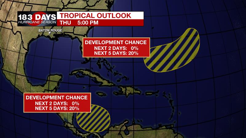
The Tropics: A broad non-tropical low pressure system is expected to form over the next couple of days several hundred miles east-southeast of Bermuda. There is a 20 percent chance of formation into early next week while the system moves southwestward passing between Bermuda and the northern Lesser Antilles.
Trending News
Another broad area of low pressure could form by early next week over the southwestern Caribbean Sea. There is a 20 percent chance of formation as it drifts slowly northward.
The Explanation: An upper level trough of low pressure will drive a cold front through the area on Friday morning. As of Thursday afternoon, showers were lagging behind the front—telling that the shallow sloped boundary is unlikely to produce any lightning. Dew points in the 60s and south winds may allow this front to create a few showers in the local area on Friday morning. Once the trough clear the area by midday, the low levels will dry out, showers will end and clouds will start to break from north to south. With a surface high pressure situated over the Ohio Valley, clear skies and light easterly winds are anticipated into Saturday morning. Beneath clear skies, the area appears poised for the first lows in the 40s of the season. The surface high will move off the East Coast by Sunday and a southeasterly wind shift will restore surface moisture and warmer than average temperatures into next week. Along with a few fast moving disturbances in a general west to east moving jet stream aloft, this moisture may be enough to cause a few periods of showers. Currently, we are favoring Monday and Thursday but this is a low confidence portion of the forecast. Timing these pockets of light rain will be easier as those days get closer.
--Josh
The WBRZ Weather Team is here for you, on every platform. Your weather updates can be found on News 2, wbrz.com, and the WBRZ WX App on your Apple or Android device. Follow WBRZ Weather on Facebook and Twitter for even more weather updates while you are on the go.
More News
