

Latest Weather Blog
Front dries out the Baton Rouge area
A cold front will actually push into the Gulf of Mexico this afternoon, swiping away a good deal of moisture. This will lead to much lower rain chances, with radar likely empty through the remainder of the week. Additionally, there should be a noticeable drop in humidity. It is still summer, and dry air actually warms more efficiently than humid air, so afternoons will be just as sweltering but Thursday and Friday mornings will be a bit more comfortable.
THE FORECAST:
Today and Tonight: Today will be mostly sunny with any isolated rain showers limited to the coast. High temperatures will make it into the low 90s, but the air may be a little less humid with light, north winds. Overnight will be clear and comfortable by August standards with lows in the low 70s. Upper 60s may be reached along and north of I-12.
Up Next: After a pleasant morning on Thursday, mostly sunny skies will send highs back into the 90s. One more comfortable morning is possible on Friday before moisture returns to the region. At first, this will be noticed via increasing humidity. Eventually, enough will be around to trigger afternoon showers and thunderstorms again by the end of the weekend and early next week.
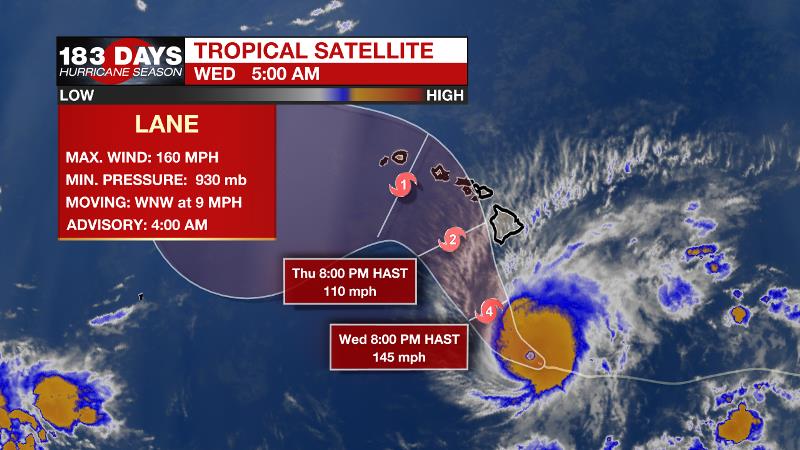
The Tropics: As we near the heart of hurricane season, the Gulf of Mexico, Caribbean Sea and Atlantic Ocean are all quiet. No development is expected over the next 5 days. In the Pacific, Hurricane Lane is a dangerous category five storm that is threatening Hawaii. Lane will move just west of the main islands Thursday through Saturday. While maximum winds of 160mph may decrease a little, serious hurricane force winds, large swells and 15 inches of rain are expected. A major hurricane has not impacted Hawaii since 1871.
Trending News
THE EXPLANATION:
Rain chances will diminish on Wednesday as an upper level trough shifts east and a cold front settles into the northern Gulf of Mexico. The front will bring drier air; dew points and even morning lows could be dropping into the upper 60s for some locations (mainly I-12 and northward) through Friday morning. The drier air warms more readily than our typical humid air though, so afternoon highs will remain just as warm. The absence of cooling showers and cloud cover could even make the heat seem more persistent. Mornings will be a bit more pleasant. Forecast models are showing an upper level ridge building over the central Gulf Coast over the weekend. This ridge will serve to keep temperatures seasonably warm as return flow results in building humidity as well. Subsidence beneath the ridge could result in lower convective coverage. The position of this ridge will be important though as a slight shift to the north, as suggested by the ECMWF model would allow for some weak, easterly waves to cross the Gulf Coast and generate showers and thunderstorms.
--Dr. Josh
The WBRZ Weather Team is here for you, on every platform. Your weather updates can be found on News 2, wbrz.com, and the WBRZ WX App. on Apple and Android devices. Follow WBRZ Weather on Facebook and Twitter for even more weather updates while you are on the go.
More News
