

Latest Weather Blog
Friday PM Forecast: fall preview coming to an end
The weather looks largely cooperative for outdoor events this weekend. A stray shower is possible, but certainly not anything of major impact. Much warmer temperatures are ahead for next week.
Next 24 Hours: Skies will stay mainly clear overnight with low temperatures taking one last run at the upper 60s. The slow return of humidity will continue on Saturday. With partly sunny skies, high temperatures will chug into the low 90s. A stray shower or thunderstorm is possible along and south of I-12 but the best chance for any rain will be immediately along the coast. Any precipitation will be short-lived.
Up Next: The forecast can be copied and pasted from Saturday into Sunday. Some changes are in store for next week. First, those small rain chances will quickly diminish. Second, a bout of late season warmth on tap. Dry and warm air aloft will lead to sunny, hot afternoons with high temperatures well into the 90s. Tuesday through the end of the week could have readings around 95 degrees. Though not quite to peak summer levels, some humidity will be noticeable as seen in overnight low temperatures around 70. CLICK HERE for your detailed 7-Day Forecast.
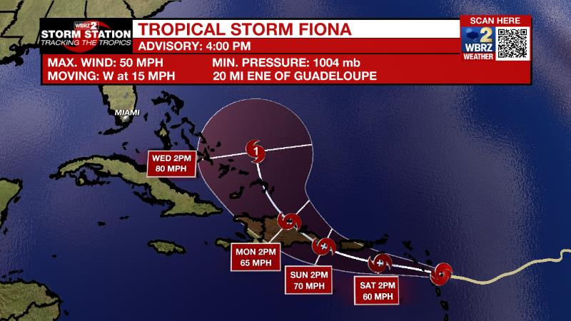
The Tropics: As of 4pm Friday, Tropical Storm Fiona was crossing over the Leeward Islands with maximum sustained winds of 50mph. Moving west at 14mph, Fiona will continue on this track but slow down over the weekend before turning west-northwest early next week. Some gradual strengthening is possible. Storm force winds and heavy rain are expected across the Leeward Islands, Virgin Islands, Puerto Rico and Hispaniola. The highest elevations of Puerto Rico could pick up about ten inches causing serious flooding.
Trending News
Disorganized showers and thunderstorms over the central tropical Atlantic Ocean are associated with the northern end of a tropical wave. There is a twenty percent chance of slow development early next week while the system moves northwestward to northward over the central subtropical Atlantic.
The Explanation: The front from earlier in the week will glide north toward the coast on Saturday. Through Sunday, this boundary will activate a few showers and thunderstorms, primarily offshore. While some of them will drift west in the weak steering winds aloft, they will interact with continued dry air, which will make it hard for them to advance inland with any strength. Generally, chances for a shower or thunderstorm are in the 30 percent range along the coast trailing off to 10 percent around I-12 and near zero into Mississippi. Early next week, an upper level ridge of high pressure will slowly build eastward over the Midwest helping to diminish the old front. Our position on the southeast side of the ridge will cause drier continental air to flow into the area from the northeast. The twofold effects will be continued dry conditions but unseasonably warm temperatures. Average high temperatures for the third week of September are in the upper 80s but it looks like with the ridge centering over the Mid-Mississippi River Valley by next Thursday, most of the workweek will feature maximums about 5 degrees above normal. The drier air aloft will mix down tot eh surface keeping humidity from returning to August levels and low temperatures will be closer to average in the upper 60s and low 70s.
--Josh
The Storm Station is here for you, on every platform. Your weather updates can be found on News 2, wbrz.com, and the WBRZ WX App on your Apple or Android device. Follow WBRZ Weather on Facebook and Twitter for even more weather updates while you are on the go.
More News
